
Steinbornshohl
|
Steinbornshohl
|
||
 Steinbornshohl (2021) |
||
| location | Groß-Umstadt , Darmstadt-Dieburg district , Hesse | |
| surface | 11,919 m² | |
| Geographical location | 49 ° 52 ' N , 8 ° 56' E | |
|
||
| Setup date | May 27, 1959 | |

The Steinbornshohl is a ravine in the district of Groß-Umstadt (City of Groß-Umstadt) in the Darmstadt-Dieburg district in southern Hesse . The deepest and narrowest loess hollow in Hesse is of cultural and historical importance and was designated as an extensive natural monument by ordinance of May 27, 1959 .
location
The Steinbornshohl is located in the Reinheimer Hügelland natural area . It is located on the eastern edge of the Groß-Umstadt district and stretches up the slope of the Hainrichsberg from the urban area in an initially east, later east-south-east direction. In the lower part there are relatively dense buildings, in the upper part the path leads through vineyards and some orchards. The hollow borders in its eastern outlet on the NSG Herrnberg von Groß-Umstadt and the vineyard location (single location Am Herrnberg ) of the Odenwald wine island .
Description and history
The Steinbornshohl (dialect "Schdammbertshoul") has been a connecting route to a Hohen Strasse and Frankfurter Strasse, which led along the ridge of the Odenwald , since Roman times . The ravine has carved its way up to 14 meters deep and steep in the loess due to running water and centuries of use with carts . It is the deepest and narrowest loess gorge in Hessen. (Occasionally the Schiffsweg-Hohl near Schaafheim was named like that, but this is due to a mix-up.) The ravine used to be 800 meters long and only ran out before the Platte (Farmerhaus restaurant). For reasons of road construction, the upper part was filled, so that the upper half of the path is almost at ground level. The height difference to the lower, ravine-like part is overcome by a long staircase.
During the Second World War , numerous passages were dug into the side walls of the ravine to protect against air raids and were later filled in again. At the lower end of the Steinbornshohl are the cellar vaults ( Ganß 's cellar) of the former swan brewery. Today a well-traveled hiking trail leads through the hollow.
Around 1890, Christoph Vogel provided evidence of Stone Age settlement based on old burns in the loess of the Steinbornshohl , which Otto Völzing corroborated in 1929 with a group of paleolithic artefacts in the brick forest.
Flora and fauna
The steep loess slopes are covered with shrubs and trees, including many locusts . Common clematis often overgrow trees. At the upper edges of the ravine, bushes form a border, in places there are loess breaks. On the north side of the upper, filled-in section of the path, there is a hedge, which consists mainly of blackthorn and hawthorn .
The woody stocks in the natural monument are a valuable habitat in which, among other things, nightingales and various types of warblers breed. Sand lizard and slow worm occur here. Bumblebees , sand bees and wild bees of the genus Halictus fly in the more open areas .

Former brewery cellars at the lower end of the ravine (2021)
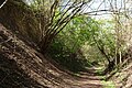
Loess walls in the Steinbornshohl (2021)
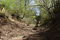
Steinbornshohl with stairs to the upper level of the path (2021)

Upper, now backfilled part of the historic ravine (2021)

From the Hainrichsberg the Steinbornshohl led down to Groß-Umstadt (2021)


Impairments
At times, the lower part of the natural monument was used as a wild rubbish dump and to deposit garden waste. In 1993, excavated earth from the nearby city cemetery with the remains of human bones was deposited there, but was later removed again.
See also
Individual evidence
- ^ Ordinance on the safeguarding of natural monuments in the Dieburg district. (PDF; 26 kB) The district committee of the Dieburg district, May 27, 1959, accessed on April 26, 2021 .
- ↑ Otto Klausing: Geographical land survey: The natural space units on sheet 151 Darmstadt. Federal Institute for Regional Studies, Bad Godesberg 1967. → Online map (PDF; 4.3 MB)
- ↑ Map of the natural monument. BürgerGIS district of Darmstadt-Dieburg. Darmstadt-Dieburg district, accessed on April 26, 2021 .
- ↑ Aerial photo of the natural monument. natureg.hessen.de, accessed on April 26, 2021 .
- ↑ a b c d e Horst Bathon, Georg Wittenberger: The natural monuments of the Darmstadt-Dieburg district with biotope tours , 2nd expanded and completely revised edition. In: Schriftenreihe Landkreis Darmstadt-Dieburg, (Ed.) District Committee of the District of Darmstadt-Dieburg - Lower Nature Conservation Authority, Darmstadt, 2016. ISBN 978-3-00-050136-4 . 243 pages. (Pp. 59-63).
- ↑ Hikable Groß-Umstadt & surroundings. Folded hiking map (PDF). City of Groß-Umstadt, accessed on April 26, 2021 .
- ↑ Odenwälder Weininsel hiking trail. (PDF). Odenwald Tourismus GmbH, accessed on April 26, 2021 .
- ↑ K. Völzing: Communications on Palaeolithic finds near Groß-Umstadt , Journal of the German Geological Society, Volume 83 (1931), p. 665