
Stone Gate (Hamburg)
.jpg)
The stone gate was a former city gate in the Hamburg city fortifications and the main gate to the east. This is where the highways towards Lübeck and Berlin began . Originally located at the end of Steinstraße , it was last located near what is now Hamburg's main train station , where several streets and squares were named.
history


The stone gate already belonged to the medieval city wall from the 13th century and was at the time at the east end of Steinstraße , from which it owes its name. In the middle of the 16th century it was moved a little further to the east, but was still in line with Steinstrasse.
When the Hamburg ramparts were expanded , it was closed in 1617 in favor of a bastion and rebuilt around 200 meters further north. Until well into the 19th century, the Steinstrasse ended blindly at the city wall, while the Landstrasse arriving from outside found no direct continuation at the Steintor, but was diverted via the Schweinemarkt into Spitalerstrasse or Steinstrasse. Only the breakthrough of Mönckebergstrasse in 1910 made it possible to have a straight line to the city center again.
After the suburb of St. Georg was included in the fortress in 1697 by an additional " Vorwerk" (roughly in the course of today's Lohmühlenstraße), the stone gate lost its military importance, but continued to serve as a border between town and country area. The outer borders of the fortress were now the Lübeck and Berlin gates .
Towards the end of the 18th century, the so-called stone gate cemeteries were laid out in front of the gate to relieve the overcrowded inner-city burial grounds. A hundred years later they had to give way to the construction of the Hamburg Central Station .
After the French occupation (1806–1814), the militarily obsolete ramparts were demolished and converted into green spaces. The old, narrow gates were replaced by new, pier-bounded passages, which were still closed after dark until the gate was lifted in 1860. The new gate structures - like those on Damm and Millerntor - were designed by the then building director Carl Ludwig Wimmel in a classical style .
After the closure of the gate in 1860 and the inclusion of St. George in the urban area in 1868, the stone gate finally lost its function and was consequently torn down.
During the construction of the underground tunnel under the tracks of the main train station , which opened in 1906, the foundations of the (older) stone gate were found. 2,000 cubic meters of brickwork had to be removed. The masonry was so deep that it reached under the base of the underground tunnel to be built. In addition, 13 m long wooden bridge bays and a pillar made of yellow clinker for the bridge in front of the gate over the moat were found.
Representations
There are no contemporary views of the older stone gates. The well-known representations by the Suhr brothers or by Cipriano Gaedechens all date from the 19th century, so they were created retrospectively and in some cases are also contradictory. They show the older stone gate (at Steinstraße) with two thick towers analogous to the Lübeck Holstentor . Another lithograph by Peter Suhr shows the gate in 1700 as a much slimmer construction without towers, but the arrangement of the church towers in the background suggests a more southerly location than at today's Steintorplatz. Gaedechens, in turn, depicted the stone gate with towers in 1738.

Stone gate around 1600 (Gebr. Suhr)

Depiction based on Suhr in Block C of the City-Hof
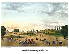
Stone gate around 1700 without towers (Gebr. Suhr)

Gaedechens stone gate from 1738, outside ...

... and seen from the inside.

The last stone gate from the outside, around 1840.


Steintorplatz and neighboring streets
.3.ajb.jpg)
The square in front of the Steintor is still designed as a square today and is called Steintorplatz , albeit with a smaller area than before. It is bordered to the south by the Museum of Art and Crafts , to the east by the acute-angled buildings between Adenauerallee and Steindamm and to the north by the Klockmannhaus . To the west, the imposing hall of the main train station limits the view. The Steintorplatz continues to play an important distribution role in the Hamburg road network. The Steintordamm (with an extension to Mönckebergstrasse and its bridging over the railway tracks) still functions as a main entrance to the city, especially for local public transport (above-ground buses, underground underground). The streets Steintorwall and Steintorweg that branch off from Steintorplatz and Steintorweg are also reminiscent of the former city gate.
Between 1633 and 1876 the Volksfest Waisengrün took place annually on the square , with which donations were raised for the former orphanage .
Web links
Individual evidence
- ^ CF Gaedechens: Hamburg. Historical-topographical and architectural reports . O. Meissner Verlag, Hamburg 1868.
- ^ Wilhelm Melhop : Historical Topography 1895-1920 . tape II , p. 425 f .
- ^ Franklin Kopitzsch , Daniel Tilgner (ed.): Hamburg Lexikon. 4th, updated and expanded special edition. Ellert & Richter, Hamburg 2010, ISBN 978-3-8319-0373-3 , pp. 735-736.
Coordinates: 53 ° 33 ′ 7.6 ″ N , 10 ° 0 ′ 33.8 ″ E