Strelitzer Strasse (Berlin)
| Strelitzer Strasse | |
|---|---|
| Street in Berlin | |
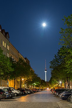
| View from Bernauer Strasse into Strelitzer Strasse at night | |
| Basic data | |
| place | Berlin |
| District | Mitte and Gesundbrunnen |
| Created | in the 19th century |
| Hist. Names | Egon-Schultz-Strasse (1966–1992) |
| Connecting roads | Wattstrasse (north) |
| Cross streets | Stralsunder Strasse (north) , Bernauer Strasse , Rheinsberger Strasse (only confluence from the east) , Anklamer Strasse, Elisabethkirchstrasse |
| use | |
| User groups | Pedestrian traffic , bicycle traffic , car traffic |
| Technical specifications | |
| Street length | 700 meters |
The Strelitzer road is about 700 meters long street in the Berlin districts of Mitte and Gesundbrunnen . It leads in a north-south direction from Stralsunder Straße to the back of the Elisabethkirche , where it joins Elisabethkirchstraße. In its course, the street crosses, among other things, Bernauer Strasse , along which the Berlin Wall stood between 1961 and 1989.
history
According to the Hobrecht plan, the traffic route was named Straße 72, Section IX . It was given its current name after the then independent town of Strelitz (today the Strelitz-Alt district of Neustrelitz) on May 29, 1862.
During the division of Germany , the northern section was in what was then the West Berlin district of Wedding, the southern section belonged to the East Berlin district of Mitte. Strelitzer Strasse was thus separated by the Berlin Wall above street level and in the ground below Bernauer Strasse . In the area, some escape aid groups had dug several escape tunnels , which were given serial numbers for the sake of clarity. The tunnel 57 ended in the backyard of the house Strelitzer Straße 55 in East Berlin. After employees of the Ministry for State Security (MfS) discovered the tunnel on October 5, 1964, an attempt to arrest the escape helpers accidentally shot GDR border guard Egon Schultz by a comrade. Until the fall of the Berlin Wall, the incident was portrayed by the Stasi as a murder by the escape helper Christian Zobel , who died in the 1980s believing he had shot a person. In honor of Schultze, a memorial plaque was put up on the first anniversary of his death and the southern section of the street was renamed Egon-Schultz-Strasse on August 12, 1966 .
After the fall of the Berlin Wall and the new responsibility of the Senate for the whole of Berlin, the street got its old name back on December 1, 1991. The earlier memorial plaque for Schultz disappeared in the 1990s. A new plaque was installed in its place in 2004.
particularities
The house numbers are assigned in the form of a horseshoe , the numbering starts at Elisabethkirchstraße and comprises a total of 73 numbers. From the outset, the residential buildings were built with transverse and rear buildings so that many families could get inexpensive living space. For example, up to 50 families can be found in one house in the Berlin address books around 1910.

There are also memorial plaques on houses on this street for Kurt Klinke (house number 18) and Gustav Elfert (house number 10), resistance fighters against National Socialism , who lived in the specified houses.
After the effects of the war and decay, new buildings such as the town houses on Mauerpark (Strelitzer Straße 54/55) have been built on this street in addition to renovated houses that have been freed from some courtyard buildings .
Two tenement houses ( Strelitzer Strasse 61 and 73) and a school complex designed by Hermann Blankenstein as 207/210. Community schools built are in the Berlin monument list.
Web links
- Strelitzer Strasse. In: Street name lexicon of the Luisenstädtischer Bildungsverein (near Kaupert )
Individual evidence
- ^ Strelitzer Strasse . In: Berliner Adreßbuch , 1910, part 3, p. 883.163803
- ↑ Representation of the residential buildings Strelitzer Strasse 54 and 55 with fourteen new buildings ( Memento from March 9, 2011 in the Internet Archive ), accessed on April 8, 2013
- ↑ Monument Strelitzer Strasse 61, tenement and commercial building, 1888/1889 Monument Strelitzer Straße 73, tenement house, 1863 Monument complex Strelitzer Straße 41/42, 207th and 210th community school, 1895/1896 by Hermann Blankenstein and M. Karchow
Coordinates: 52 ° 32 '8.9 " N , 13 ° 23' 40.7" E

