Sunbury County
| Sunbury County | |
|---|---|
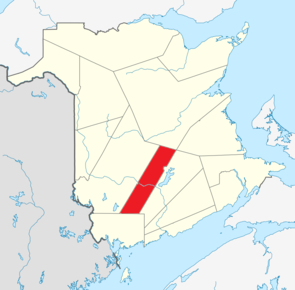
 Location of the region in New Brunswick
|
|
| Basic data | |
| Country | Canada |
| province |
New Brunswick
|
| Coordinates : | 45 ° 55 ′ N , 66 ° 20 ′ W |
| Residents | 27,644 (as of 2016) |
| surface | 2,696.53 km² |
| Population density | 10.3 inhabitants / km² |
| founding | 1785 |
| Time zone : | Atlantic Standard Time ( UTC −4) Atlantic Daylight Time ( UTC −3, daylight saving time) |
Sunbury County ( French Comté de Sunbury ) is a county in the Canadian province of New Brunswick . It covers an area of 2696.53 km². The population was 27,644 in 2016.
location
The county is located in the central southwest of the province.
Administrative division
cities and communes
There are 3 parishes in Sunbury County:
| Surname | status | Area km 2 |
Population 2016 |
Parish |
|---|---|---|---|---|
| Fredericton Junction | Village | 23.85 | 704 | Gladstone |
| Oromocto | Town | 22.44 | 9223 | Burton |
| Tracy | Village | 29.46 | 608 | Gladstone |
Indian reservations
There is a reservation in Sunbury County:
| Surname | Area km 2 |
Population 2016 |
Parish |
|---|---|---|---|
| Oromocto 26 | 1.80 | 327 | Burton |
Parishes
The county is divided into 7 parishes:
- Blissville Parish
- Burton Parish
- Gladstone Parish
- Lincoln Parish
- Maugerville Parish
- Northfield Parish
- Sheffield Parish
Web links
Commons : Sunbury County - collection of pictures, videos, and audio files
Individual evidence
- ↑ a b c d Census Profile, 2016 Census . Statistics Canada. Retrieved September 1, 2018.
