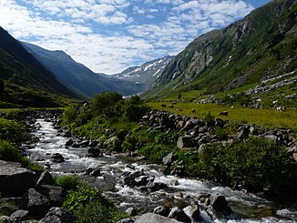
Sunderbach (Ziller)
| Sunderbach | ||
|
The Sunderbach near the Rachhüttenalm in the Sundergrund |
||
| Data | ||
| Water code | AT : 2-8-214-13 | |
| location | Tyrol , Austria | |
| River system | Danube | |
| Drain over | Ziller → Inn → Danube → Black Sea | |
| source | below the Hörndljoch in the Zillertal Alps 47 ° 3 ′ 29 ″ N , 12 ° 0 ′ 25 ″ E |
|
| Source height | 2159 m above sea level A. | |
| muzzle | In the Au in den Ziller coordinates: 47 ° 7 ′ 19 ″ N , 12 ° 0 ′ 31 ″ E 47 ° 7 ′ 19 ″ N , 12 ° 0 ′ 31 ″ E |
|
| Mouth height | 1260 m above sea level A. | |
| Height difference | 899 m | |
| Bottom slope | 11% | |
| length | 8.2 km | |
| Catchment area | 35.8 km² | |
| Communities | Brandberg | |
The Sunderbach is an approximately 8 km long left tributary of the Ziller in the Zillertal Alps in Tyrol .
The stream rises at the head of the Sundergrund valley below the Hörndljoch in the area of the Mösla and Langeben moors. It then flows north through the Sundergrund and flows into the Ziller in the In der Au area. In the Sundergrund, numerous smaller streams flow into it, the most important of which are the Hasenkarbach, the Kainzenkarbach and the Rachkarbach, all of which flow from the left. Because of the steep slopes, many of the tributaries have formed waterfalls.
The natural catchment area of the Sunderbach is 35.8 km², of which 3.66 km² (10%) are glaciated (as of 1988). The highest point in the catchment area is the Hintere Stangenspitze at 3225 m above sea level. A.
Above the Schönhüttenalm at around 1800 m above sea level. A. the Sunderbach is captured and diverted into the Zillergründl reservoir . Above this, the overall ecological status is classified as very good, below it as moderate or bad.
Individual evidence
- ↑ a b c d e TIRIS - Tyrolean spatial information system
- ^ Max H. Fink, Otto Moog, Reinhard Wimmer: Flowing waters - natural areas of Austria . Federal Environment Agency, Monographs Volume 128, Vienna 2000, p. 47 ( PDF; 475 kB )
