
Sutherland Springs
| Sutherland Springs | |||
|---|---|---|---|
Location in Texas
|
|||
| Basic data | |||
| Foundation : | 1854 | ||
| State : | United States | ||
| State : | Texas | ||
| County : | Wilson County | ||
| Coordinates : | 29 ° 16 ′ N , 98 ° 3 ′ W | ||
| Time zone : | Central ( UTC − 6 / −5 ) | ||
| Height : | 143 m | ||
| Postal code : | 78161 | ||
| FIPS : | 71396-48 | ||
| GNIS ID : | 1369438 | ||
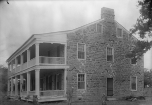 Whitehall, HABS - 1936 image |
|||

Sutherland Springs is an unincorporated community in the northern part of Wilson County in the US state of Texas . The location is on US Highway 87 , where it crosses Farm Road 539, about 21 miles east of central San Antonio . Old Sutherland Springs is on the south bank of Cibolo Creek and New Sutherland Springs is on the north bank. According to the information in the Handbook of Texas , the place had 362 inhabitants (as of 2000).
Whitehall , a listed structure on the National Register of Historic Places , is located in Sutherland Springs.
Rampage at the First Baptist Church
On November 5, 2017 , a man in the First Baptist Church shot dead at least 26 people and injured around two dozen others.
supporting documents
- ↑ Richard McCaslin: Sutherland Springs, TX ( English ) In: Handbook of Texas . Texas State Historical Association. Retrieved November 6, 2017.
- ↑ Texas church shooting leaves many dead ( English ) In: BBC News . British Broadcasting Corporation. November 5, 2017. Retrieved November 6, 2017.
Web links
Commons : Sutherland Springs - collection of images, videos and audio files