Tømmerneset
| Tømmerneset | ||||
|---|---|---|---|---|
|
||||
| Basic data | ||||
| Country | Norway | |||
| Province (fylke) | North country | |||
| Municipality (commune) : | Hamarøy | |||
| Coordinates : | 67 ° 54 ′ N , 15 ° 52 ′ E | |||
| Height : | 51 moh. | |||
Tømmerneset is a village in Hamarøy municipality in the Salten region in the Norwegian province of Nordland .
The place
The place is located 51 meters above the sea on the east coast of the lake Rotvatnet (also Nervatnet or Lule Ruohcajávri called) and (at the junction of the road N835 835 Riksvei ) with the 8-meter climbing tunnel from the E6 , about 50 km south of the municipal administrative center Oppeid . The postal address is 8260 Innhavet .
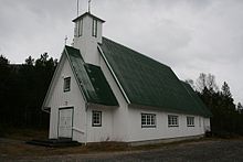
In Tømmerneset on the east bank of the Rotvatnet is the white wooden church of Tømmernes ( Tømmernes kirke ), built in 1952 ; it serves the southern part of Hamarøy municipality and has space for 110 people.
history
During the Second World War , the Wiking Task Force of the Todt Organization of the German occupying forces operated a branch with a forced labor camp in Tømmerneset , from which Soviet and Serbian prisoners of war were used to build the polar railway ( Fauske - Tysfjord section ). Most of these prisoners were killed in the sinking of the Rigel prisoner transport by British planes on November 27, 1944.
Individual evidence
- ↑ Tømmerneset. yr.no, accessed January 28, 2013 (Norwegian).
- ↑ Tømmerneset. In: Store norske leksikon. Retrieved January 28, 2013 (Norwegian).


