Tamaki River (Motukorea Channel)
|
Tamaki River Tāmaki River |
||
|
The river as seen from Mount Wellington looking southwest |
||
| Data | ||
| location | Auckland Council , North Island , New Zealand | |
| source | 1 km southwest of Middlemore Hospital in the Papatoetoe neighborhood of Auckland Council 36 ° 57 ′ 49 ″ S , 174 ° 50 ′ 25 ″ E |
|
| Source height | 11 m | |
| muzzle | in the Motukorea Channel coordinates: 36 ° 50 ′ 43 ″ S , 174 ° 53 ′ 19 ″ E 36 ° 50 ′ 43 ″ S , 174 ° 53 ′ 19 ″ E |
|
| Mouth height | 0 m | |
| Height difference | 11 m | |
| Bottom slope | around 0.58 ‰ | |
| length | around 19 km | |
| Big cities | Auckland | |
|
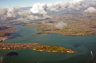
Lower part of the river with its estuary (on the right in the picture) |
||
The Tamaki River , in the language of the Māori Tāmaki written, is a river in the urban area of the Auckland Council on the North Island of New Zealand .
geography
The headwaters of the river, which winds around 19 km to the northeast, is located around 1 km southwest of Middlemore Hospital in the Papatoetoe district of the Auckland Council . The entire river is under the influence of the tides and flows into the Motukorea Channel between West Tamaki Head and Musick Point off Browns Island .
The Tamaki River has several smaller tributaries, such as Otara Creek , Pakuranga Creek, and Wakaaranga Creek on its east side and Otahuhu Creek and Panmure Basin on its west side.
The districts of Otahuhu , Otara , Mount Wellington , Tamaki and Howick flank the river on both sides.
Yacht and ferry port
The Tamaki River has with the Half Moon Bay Marina in the lower course of the river on the east bank a marina, from which a ferry to the port of Auckland and after Waiheke Iceland exists. Since the area of the Tamaki River east of the Panmure Basin is considered to be quite protected, many boats are anchored in this section in the middle of the river in the absence of a marina.
Web links
- Margaret McClure : Auckland places - Tāmaki River . In: Te Ara - the Encyclopedia of New Zealand . Ministry for Culture & Heritage , October 5, 2016, accessed May 29, 2018 .

