Tanır
| Tanır | ||||
|
||||
 Tanır |
||||
| Basic data | ||||
|---|---|---|---|---|
| Province (il) : | Kahramanmaraş | |||
| District ( ilçe ) : | Afşin | |||
| Coordinates : | 38 ° 25 ' N , 36 ° 55' E | |||
| Height : | 1235 m | |||
| Residents : | 2,545 (2012) | |||
| Telephone code : | (+90) 344 | |||
| Postal code : | 46560 | |||
| License plate : | 46 | |||
| Structure and administration (as of 2016) | ||||
| Muhtar : | Gökhan Yıldırım | |||
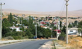
Tanır (former name Tanur , Byzantine Ptandaris ) was a municipality in the Afşin district of the Turkish province of Kahramanmaraş until 2012 . Since a regional reform, Kahramanmaraş is a Büyükşehir Belediyesi (big city commune) and Tanır is a district of the district center Afşin. The place is located 20 kilometers north of Afşin and about 95 kilometers north of the provincial capital. The Hurman Çayı flows through the settlement and flows into the Ceyhan in the south . A connecting road from Afşin to Sarız runs through the village from south to north . The foothills of the Binboğa Dağları Mountains lie northwest of the town .
In the region of Yugarı Boğazı (Upper Gorge) in the northeast of Tanır, the late Hittite rock inscription of Tanır is engraved on a steep rock face on the west bank of the Hurman . The fortress Hurman Kalesi lies about ten kilometers northwest of the river .

