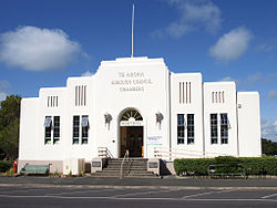
Te Aroha
| Te Aroha | ||
| Geographical location | ||
|
|
||
| Coordinates | 37 ° 33 ' S , 175 ° 43' E | |
| Region ISO | NZ-WKO | |
| Country |
|
|
| region | Waikato | |
| District | Matamata-Piako District | |
| Ward | Te Aroha Ward | |
| Residents | 3 906 (2013) | |
| height | 24 m | |
| Post Code | 3320 | |
| Telephone code | +64 (0) 7 | |
| UN / LOCODE | NZ TAR | |
| Photography of the place | ||
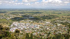
 Te Aroha from Mount Te Aroha seen from |
||
Te Aroha is a small town in the Matamata-Piako District of the Waikato regionon the North Island of New Zealand .
Origin of name
According to a legend that reads something depending on the source of different, climbed Rāhiri , a Māori - Chief of the Iwi Te Arawa from the area around Whakatane and son of the Bay of Plenty - Chiefs Kahu Mata Momoe , on a return trip to his tribe the Mountain that would later be called Mount Te Aroha . Rāhiri is said to have been so overwhelmed by the view of land and sea that he had from up there that he is said to have exclaimed " Aroha ki tai! Aroha ki uta! ", Which in New Zealand meant " Love to the sea! Love to the shore! "(German: love for the sea! love for the coast!) is translated. It is interpreted that it meant the sea and the land.
Others from the Te Arawa tribe say that it was Kahumatamomoe , son of Tamatekapua , the leader of the Te Arawa canoe, who did this, and in Waikato this act is ascribed to another leader.
Whatever the story, the name aroha (love) became uta (land) and tai (lake), love for the land and the sea, and the mountain was initially Te Aroha a uta, Te Aroha a called tai . Later, Te Aroha was shortened for the mountain and the resulting settlement was named after the mountain.
geography
The city is located about 46 km northeast of Hamilton and 47 km south-southeast of Thames in the Waihou-Piako Basin on the western flank of the Kaimai Range . State Highway 26 , which connects Te Aroha with Hamilton and northwards with the Coromandel Peninsula, runs through the town . Northeast of the city is Mount Te Aroha , 952 m high and namesake of the place. The Waihou River runs through Te Aroha , and north of the city is the marshy lowlands of the Hauraki Plains .
history
Te Aroha was officially founded on November 25, 1880 with the opening of the Waiorongomai gold fields, 3 km to the southeast . While the village of Waiorongomai developed through gold mining, Te Aroha grew into a small town in 1886 and into a borough in 1896 (small town with its own administration).
The development of Te Aroha but was essentially donated by the hot spring of the place by the Maori - chief , Te Mokena Hau affected to the British Crown 1882nd The hot mineral spring, which was previously used by the local Māori , was now available to Europeans seeking relaxation. The railway connection built in 1883 brought tourists to Te Aroha , and with the opening of the Te Aroha Domain in 1989, Te Aroha quickly developed into a nationally renowned health resort and recreation resort under the control of the Minister of Lands .
On June 9, 1883, the first newspaper, Te Aroha News and Upper Thames Advocate, appeared . It was later renamed Te Aroha News and was published until 1986.
In 1895 the " gold rush " in the neighboring Waiorongomai was over, so that the population decreased from over 2,000 inhabitants to a few hundred within five years. Many of the buildings in the gold rush town were pulled on rollers through the valley to Te Aroha and rebuilt there.
Te Aroha maintained its importance as a health resort and resort until concerns about the purity and quality of the bathing water in the domain arose in the early 1980s . In 1983 the bath was closed and dismantled. However, the buildings of the Te Aroha Domain were preserved and are now a listed building. The main building, the Cadman Bath House , is now used as the local museum.
population
In the 2013 census, the town had 3,906 inhabitants, 3.7% more than in the 2006 census.
economy
The main economic factor in the region around Te Aroha today is the dairy industry with the milk processing industry. Sheep breeding, meat processing, wood processing and fertilizer production are other branches of business. The hot springs still attract tourists and those looking for relaxation, but this branch of the economy no longer has the significance of the previous years.
Geyser Mokena
The only one in the Southern Hemisphere occurring cold water geyser is located in Te Aroha . The Mokena Geyser comes from a depth of around 70 m and produces around 28,000 liters of crystal clear water every day at an interval of 40 minutes, which is between 75 and 85 ° C warm.
The geyser was named after the Māori - Chief Mokena Te Hau named.
Personalities
- Edward James O'Donoghue (1900–1994), English billiards and snooker player
See also
literature
- Te Aroha . In: Alexander Hare McLintock (Ed.): An Encyclopaedia of New Zealand . Wellington 1966 ( online [accessed December 13, 2015]).
Web links
- Homepage . Te Aroha,accessed June 23, 2014.
- Homepage . Te Aroha Museum,accessed June 23, 2014.
Individual evidence
- ↑ a b 2013 Census QuickStats about a place : Te Aroha . Statistics New Zealand , accessed June 23, 2014 .
- ↑ a b Te Aroha . (PDF 14 kB) Tauranga Library , accessed on June 23, 2014 (English).
- ↑ The Legend of Mt Te Aroha . Te Aroha , accessed May 19, 2019 .
- ↑ Topo250 maps . Land Information New Zealand , accessed October 17, 2017 .
- ^ Te Aroha I-Site Visitor Center (ed.): Te Aroha a brief history . Te Aroha 2010 (English, information sheet).
- ^ A b Gold Fever in the Waiorongomai . Te Aroha , accessed May 19, 2019 .
- ↑ Information Center Te Aroha (Ed.): Te Aroha - Hot Springs Domain . Te Aroha March 1, 2004 (English, brochure).
- ^ Te Aroha News . Paperpast , accessed June 23, 2014 .
- ↑ Te Aroha . In: An Encyclopaedia of New Zealand . 1966 (English).
- ↑ a b Walks - Mokena Geyser . Te Aroha , accessed May 19, 2019 .
- ^ Mokena Geyser Access . Matamata Piako District Council , accessed January 10, 2015 .


