Tekes (river)
|
Tekes Текес өзені, 特克斯 河, Tekes He |
||
|
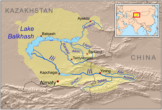
Course of the Tekes in the southeast of the catchment area of Lake Balkhash |
||
| Data | ||
| location |
Almaty ( Kazakhstan ), Xinjiang ( PR China ) |
|
| River system | Ili | |
| Drain over | Ili → Lake Balkhash | |
| Headwaters | in the extreme east of the Terskej-Alatau 42 ° 37 ′ 19 ″ N , 79 ° 32 ′ 30 ″ E |
|
| Association with |
Künes zum Ili Coordinates: 43 ° 34 ′ 45 ″ N , 82 ° 32 ′ 51 ″ E 43 ° 34 ′ 45 ″ N , 82 ° 32 ′ 51 ″ E
|
|
| length | 438 km | |
| Catchment area | 29,600 km² | |
| Discharge at the gauge near the mouth |
MQ |
270 m³ / s |
| Right tributaries | Akeyazi , Kekesu | |
| Small towns | Tekes | |
The Tekes ( Kazakh Текес өзені , Chinese 特克斯 河 , Pinyin Tèkèsī Hé ) is the left or southern source river of the Ili in Kazakhstan and China ( Central Asia ).
It rises in the far east of the Terskej-Alatau on the northern slope of the central Tianshan Mountains in the triangle Kyrgyzstan- Kazakhstan-China. Its source is there in the southeast of Kazakhstan, just north of the Dschengisch Tschokusu , the highest mountain in this high mountain range at 7439 m . From there, the water-rich Tekes flows in a north-easterly direction across the border into the Uyghur Autonomous Region of Xinjiang (north-western China) and through an ever-widening high mountain valley. He passes the Ili Mountains , a part of the Tianshan, which rise up to the south . At the end of the valley, the Tekes flows into the Künes , the actual source river or upper reaches of the Ili , which flows in from the east. The Tekes has a length of 438 km. The river freezes between December and March. The mean discharge (MQ) near the mouth is 270 m² / s. The water from the Tekes is used for irrigation .
Individual evidence
- ↑ a b c Article Tekes in the Great Soviet Encyclopedia (BSE) , 3rd edition 1969–1978 (Russian)
