Devil's Kitchen (Obergünzburg)
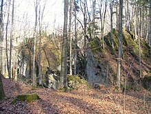
The Teufelsküche is a landslide near Obergünzburg in the Swabian district of Ostallgäu in Bavaria .
location
The slide is located in the valley of the eastern Günz between Obergünzburg and Ronsberg . It consists of boulders as high as a house that broke out of the steep face of the valley after the last ice age and rolled or slid down the slope.
Emergence
The gravel from which the Nagelfluh blocks of the Teufelsküche and the steep face above are made was created in the Mindelkaltzeit 475,000 to 370,000 years ago. During this time the Iller glacier reached its greatest extent and deposited layers of gravel up to 25 meters thick . The individual stones were connected to one another by lime and formed a conglomerate called the Nagelfluh .
The Eastern Günz dug itself deep through the ice age gravel into the underlying layer of the freshwater molasse . These sediments , consisting of sand and marl , formed an unstable subsoil, so that after the Würm Cold Age , the most recent large-scale glaciation in the Alpine region , which ended 10,000 years ago, large-scale rockfalls occurred.
Geotope
The Teufelsküche Obergünzburg has been designated by the Bavarian State Office for the Environment (LfU) as a geoscientifically valuable geotope (geotope number: 777R001) and a natural monument . It was also awarded the official seal of approval for Bavaria's most beautiful geotopes by the LfU .
reachability
On the road between Obergünzburg and Ronsberg there is a small parking lot with a sign where a forest path branches off. From there, the Teufelsküche can be reached on foot in a few minutes.
Legend
According to legend, hundreds of years ago a man lived with his wife and child in today's Teufelsküche. The plants that were collected and the animals shot during the hunt were prepared in the rock kitchen. One day the family was poisoned by blue cherries and the man cursed the place right before he died.
Web link
Individual evidence
- ^ Bavarian State Office for the Environment: Teufelsküche near Obergünzburg . In: Hundred Masterpieces - The Most Beautiful Geotopes in Bavaria. Munich 2012, ISBN 978-3-936385-89-2 , pp. 224f.
- ↑ a b Bavaria's most beautiful geotopes, Teufelsküche Obergünzburg (accessed on November 27, 2017)
- ^ Bavarian State Office for the Environment, Geotope Teufelsküche N von Obergünzburg (accessed on March 22, 2020).
- ↑ Teufelsküche and Dengelstein Allgäu excursions
- ↑ Archived copy ( Memento of the original from May 22, 2011 in the Internet Archive ) Info: The archive link was inserted automatically and has not yet been checked. Please check the original and archive link according to the instructions and then remove this notice. Caves near Obergünzburg
Coordinates: 47 ° 52 ′ 30.5 ″ N , 10 ° 24 ′ 55.4 ″ E

