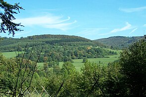
Thuringian valley
| Thuringian valley | ||
|---|---|---|
|
View to Atterode, across the Thuringian Valley |
||
| location | Thuringia , Germany | |
| Waters | Farnbach | |
| Geographical location | 50 ° 49 '19 " N , 10 ° 23' 14" E | |
|
|
||
| rock | Granite , gneiss , Zechstein | |
| length | 3 km | |
The Thuringian Valley is an approximately three kilometer long incision in the Thuringian Forest in the Wartburg district .
Location and course
The Thuringian Valley begins near the former Krätzersrasen holiday property below the Dreiherrenstein on the Great Weissenberg and ends with the Farnbach infiltration below Atterodes . From then on to Bairoda it lost the shape of an open valley; only a small trickle leads past the Katzenstein . The name Thuringian Valley is not in use for the following kilometers of the stream up to the confluence with the Werra .
nature
Mixed beech forest is predominant below the Krätzersrasen. At Atterode the valley widens so that meadows are now predominant. Between Burgberg and Katzenstein, the now very narrow valley is again wooded.
The Thuringian Valley is framed on the right by the Schnepfenberg (677 m), Bommelhauck (684 m) and Weißer Stein (625 m) and on the left by the Lower Beerberg (711 m), Rennwegskopf (729 m) and Judenkopf (712 m). At the lower end of the valley are the Katzenstein (455 m; an extension of the Hohe Klinge ) and the Linsenkopf (458 m; an extension of the Burgberg).
particularities
In the Bad Liebenstein Zechstein belt, chemical weathering resulted in a number of caves and grottos (see also Altensteiner Höhle ). In this context, there is also the so-called Farnbach infiltration near the Gleisdreieck – Hohe Klinge hiking trail. The Farnbach only carries water below this area when there is heavy rainfall. Hydraulic connections between this point, the waterfall in the ground at the Hotel Kaiserhof in Bad Liebenstein and the drinks hole - a spring that is only active at times between Bad Liebenstein and Steinbach - could be verified. Both points are more than a kilometer away from the infiltration.
Individual evidence
- ↑ Hydrogeological map of Thuringia from the Thuringian State Institute for Environment and Geology (PDF; 4.37 MB) ( Even finer maps are available for each district .)

