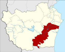
Amphoe Tha Yang
|
Tha Yang ท่ายาง |
|
|---|---|
| Province: | Phetchaburi |
| Surface: | 736.7 km² |
| Residents: | 85,183 (2013) |
| Population density : | 109.7 U / km² |
| ZIP : | 76130 |
| Geocode : | 7605 |
| map | |

|
|
Amphoe Tha Yang ( Thai : อำเภอ ท่ายาง ) is a district ( Amphoe - administrative district) in the southern part of Phetchaburi Province . Phetchaburi Province is located in the southwestern part of the central region of Thailand .
geography
Neighboring districts (from the north clockwise): the Amphoe Mueang Phetchaburi , Ban Lat , Kaeng Krachan of the Province of Phetchaburi, Amphoe Hua Hin of the Province of Prachuap Khiri Khan , Amphoe Cha-am in turn from the Province of Phetchaburi and the Gulf of Thailand .
history
This county was established by the government in 1910 under the name Yang Yong. Originally, the western part of the district, which is now part of the Kaeng Krachan district, was a mountainous area with dense forest. The forest consisted mainly of Makha (Afzelia xylocarpa) , Takhian ( ironwood , Hopea odorata ) and Yang trees (Gardschan balm, Dipterocarpus alatus ). Therefore, the district was renamed Tha Yang (literally the pier of the Yang trees ) in 1939 .
administration
Provincial Administration
The district of Tha Yang is divided into twelve tambon ("sub-districts" or "parishes"), which are further subdivided into 119 muban ("villages").
| No. | Surname | Thai | Muban | Pop. |
|---|---|---|---|---|
| 1. | Tha Yang | ท่ายาง | 10 | 18,085 |
| 2. | Tha Khoi | ท่า คอย | 11 | 12,483 |
| 3. | Yang Yong | ยาง หย่อง | 5 | 3,616 |
| 4th | Nong Chok | หนองจอก | 14th | 7,429 |
| 5. | Map Pla Khao | มา บ ปลาเค้า | 11 | 3,958 |
| 6th | Tha Mai Ruak | ท่า ไม้ รวก | 13 | 9,058 |
| 7th | Wang Khrai | วัง ไคร้ | 10 | 5,235 |
| 11. | Klat Luang | กลัด หลวง | 11 | 7.005 |
| 12. | Puek Tian | ปึก เตียน | 4th | 2,043 |
| 13. | Khao Krapuk | เขา กระปุก | 14th | 7,496 |
| 14th | Tha Laeng | ท่า แลง | 10 | 5,990 |
| 15th | Ban Nai Dong | บ้าน ใน ดง | 6th | 2,785 |
Local administration
There are four municipalities with "small town" status ( Thesaban Tambon ) in the district:
- Tha Mai Ruak (Thai: เทศบาล ตำบล ท่า ไม้ รวก ) consisting of the complete tambon Tha Mai Ruak.
- Tha Yang (Thai: เทศบาล ตำบล ท่ายาง ) consisting of the complete Tambon Tha Yang and parts of the Tambon Tha Khoi.
- Nong Chok (Thai: เทศบาล ตำบล หนองจอก ) consisting of parts of the Tambon Nong Chok.
- Tha Laeng (Thai: เทศบาล ตำบล ท่า แลง ) consisting of the complete tambon Tha Laeng.
In addition, there are nine " tambon administration organizations " ( องค์การ บริหาร ส่วน ตำบล - Tambon Administrative Organizations, TAO)
- Tha Khoi (Thai: องค์การ บริหาร ส่วน ตำบล ท่า คอย ) consisting of parts of the Tambon Tha Khoi.
- Yang Yong (Thai: องค์การ บริหาร ส่วน ตำบล ยาง หย่อง ) consisting of the complete tambon Yang Yong.
- Nong Chok (Thai: องค์การ บริหาร ส่วน ตำบล หนองจอก ) consisting of parts of the Tambon Nong Chok.
- Map Pla Khao (Thai: องค์การ บริหาร ส่วน ตำบล มา บ ปลาเค้า ) consisting of the complete tambon Map Pla Khao.
- Wang Khrai (Thai: องค์การ บริหาร ส่วน ตำบล วัง ไคร้ ) consisting of the complete tambon Wang Khrai.
- Klat Luang (Thai: องค์การ บริหาร ส่วน ตำบล กลัด หลวง ) consisting of the complete tambon Klat Luang.
- Puek Tian (Thai: องค์การ บริหาร ส่วน ตำบล ปึก เตียน ) consisting of the complete tambon Puek Tian.
- Khao Krapuk (Thai: องค์การ บริหารส่วน ตำบล เขา กระปุก ) consisting of the complete tambon Khao Krapuk.
- Ban Nai Dong (Thai: องค์การ บริหาร ส่วน ตำบล บ้าน ใน ดง ) consisting of the complete tambon Ban Nai Dong.
Individual evidence
- ↑ พระราชกฤษฎีกา เปลี่ยน นาม อำเภอ กิ่ง อำเภอ และ ตำบล บาง แห่ง พุทธศักราช ๒๔๘๒ . In: Royal Gazette . 56, No. 0 ก , April 17, 1939, pp. 354-364.
- ↑ 2013 population statistics ( Thai ) Department of Provincial Administration. Retrieved September 11, 2014.
Web links
Coordinates: 12 ° 58 ' N , 99 ° 53' E
