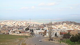
Thala (Tunisia)
| Thala |
||
|---|---|---|
| administration | ||
| Country |
|
|
| Governorate | Kasserine | |
| Délégation (s) | Thala | |
| Demographics | ||
| population | 37,128 pop (2014) | |
| geography | ||
| height | 1000 m | |
|
|
||
| Coordinates | 35 ° 35 ′ N , 8 ° 40 ′ E | |
Thala (sometimes also Talah ; Arabic تالة, DMG Tāla ) is a city with around 15,000 and a delegation with around 37,000 inhabitants in western Tunisia in the Kasserine Governorate ; it is the highest city in the country.
location
Thala lies at an altitude of approx. 970 to 1020 m above sea level. d. M. in the west of Tunisia in the dorsal of the Tell Atlas a good 25 kilometers east of the Algerian border. The state capital Tunis is approx. 243 km (driving distance) away, the city of Kasserine is approx. 53 km to the southeast and the neighboring city of Haïdra is approx. 25 km to the west.
economy
The region's economy is dominated by agriculture , particularly animal husbandry . Nearby are cacti planted the fruits themselves but are increasingly in demand in Tunisia and Europe. There are marble - and lime - quarries whose stone is further processed in a state-owned factory.
history
Thala was a former Berber settlement ; the Romans built a temple, parts of which have survived. The Muslim Arabs conquered the region in the 7th century.
As in many cities in the region, clashes between demonstrators and security forces broke out in Thala during the Tunisian Revolution in January 2011.
See also
Web links
- Short city description, photos (English)
Individual evidence
- ↑ Census 2004 + 2014
- ↑ Unrest claims 14 lives. In: Focus Online . January 10, 2011, accessed January 8, 2012 .


