Tichelrütibach
| Tichelrütibach | ||
| Data | ||
| Water code | CH : ZH101731 | |
| location |
Switzerland
|
|
| River system | Rhine | |
| Drain over | Gockhuserbach → Breitibach → Glatt → Rhine → North Sea | |
| source | in Gockhausen 47 ° 22 ′ 52 ″ N , 8 ° 36 ′ 10 ″ E |
|
| Source height | 559 m above sea level M. | |
| muzzle | in the Breitibach coordinates: 47 ° 23 '18 " N , 8 ° 36' 18" E ; CH1903: 688 071 / 249 260 47 ° 23 '18 " N , 8 ° 36' 18" O |
|
| Mouth height | 450 m above sea level M. | |
| Height difference | 109 m | |
| Bottom slope | 11% | |
| length | 1 km | |
| Catchment area | approx. 20 ha | |
| Communities | Dubendorf | |
|
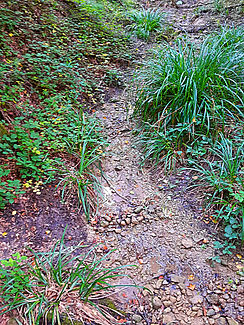
Tichelrütibach below Gockhausen |
||
The Tichelrütibach is a one kilometer long right tributary of the Gockhuserbach in the municipality of Dübendorf in the Swiss canton of Zurich . It drains an area of around 20 hectares on the eastern slope of the Adlisberg .
course
The stream rises on the lower edge of the village of Gockhausen at 559 m above sea level. M. On maps from 1950 and earlier, the beginning of the brook is shown a little further up in the adjacent, now built-up area to the southeast.
Initially it flows in a north-westerly direction along the edge of the forest. After about 50 meters it makes a curve and now flows on a north-easterly course through the forest area north of the Tichelrüti , in which it has formed a small ravine . In the lower slope area of the Adlisberg shortly before the edge of the forest in the Glatttal, it makes a sharp curve to the northwest and finally flows a little later into the Gockhuserbach , of which it is the most important tributary.
Individual evidence
- ↑ a b Geographic Information System of the Canton of Zurich
- ↑ a b Geoserver of the Swiss Federal Administration ( information )


