Breitibach
|
Breitibach Schlossbach |
||
|
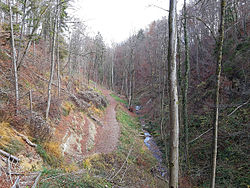
Waterfall on the Breitibach in the Schlosstobel |
||
| Data | ||
| Water code | CH : 2294 | |
| location |
Switzerland
|
|
| River system | Rhine | |
| Drain over | Glatt → Rhine → North Sea | |
| source | in the Chli Bannholz forest near Geeren 47 ° 22 ′ 15 ″ N , 8 ° 36 ′ 20 ″ E |
|
| Source height | 620 m above sea level M. | |
| muzzle | Tannery in Dübendorf Coordinates: 47 ° 24 ′ 3 ″ N , 8 ° 36 ′ 30 ″ E ; CH1903: 688 292 / 250654 47 ° 24 '3 " N , 8 ° 36' 30" O |
|
| Mouth height | 430 m above sea level M. | |
| Height difference | 190 m | |
| Bottom slope | 45 ‰ | |
| length | 4.2 km | |
| Catchment area | 4.27 km² | |
| Discharge at the Dübendorf A Eo gauge : 4.27 km² |
MQ Mq |
70 l / s 16.4 l / (s km²) |
| Left tributaries | Geerenbach , Gockhuserbach , Chämmertenbach | |
| Communities | Dubendorf | |
The Breitibach (also called Schlossbach in the upper reaches ) is a 4.2 kilometer long tributary to the left of the Glatt in the municipality of Dübendorf in the Swiss canton of Zurich . With the exception of the catchment area of the Sagentobelbach, it drains the entire northern slope of the Adlisberg , an area of around 4.3 square kilometers. Its catchment area has a river length of 14.3 kilometers.
geography
course
The Breitibach rises on the eastern slope of the Adlisberg on Langweg in the Bannholz forest area at 620 m above sea level. M. He enters a clearing lined with fields a little below at Geeren . Up to the confluence of the Spitzwiesenbächli from the right, about 340 meters below the source, it flows in an easterly direction, before it takes a north-easterly course here. 120 meters further on, it takes up the Rütibächli , which also rises on Langweg, and flows into the Breitibach from the right, which from here also runs under the ground. After another 70 meters, he takes up the Weidbächli from the left , which was also moved under the fields on its last section. The stream continues to flow 260 meters below the ground until it comes to the surface again when it reaches the Eichholz forest area .
The stream now flows through the Schlosstobel , which enters the Glatttal a little below the Dübelstein ruins near Schlossbreiti , and is now called Breitibach . It now flows to the northwest past the eastern edge of Dübendorf and is bordered by fields. In the Fallmen area , it runs underground for around 140 meters. Then he takes the Geerenbach (also called Chirchbach ) and the Gockhuserbach on the left. After the mouth of the Chämmertenbach it turns to the northeast, flows through the settlement area of Dübendorf for the last 650 meters and flows into the Glatt at the tannery.
Tributaries
- Spitzwiesenbächli ( right ), 0.1 km
- Rütibächli ( right ), 0.5 km
- Weidbächli ( left ), 0.2 miles
-
Geerenbach ( left ), 2.3 km
- Ratzenhaldenbach, 1.2 km
-
Gockhuserbach ( left ), 2.1 km
- Lattenbach, 0.1 mi
- Tennmoosbächli, 0.3 miles
- Tichelrütibach , 1 km
- Chämmertenbach ( left ), 2 km
history
The stream used to have a different course, as can be seen on older maps. At that time it was called Kirchbach , the Breitibach was the name of the Gockhuserbach . Already in the hamlet Fallmen led to the 1950 years of Geerenbach in Chirchbach . Following the north-eastern direction of the Geerenbach , the creek flowed through the center of today's Dübendorf district of Wil and from there to the north and later to the northwest and southwest past the outskirts of Dübendorf. Today the Untere Geerenstrasse , the Wilstrasse and the Kirchbachstrasse follow the old course. The confluence of the Kirchbach in the Glatt was about 200 meters further east than the current confluence of the Breitibach. The Gockhuserbach and the Chämmertenbach did not flow into the Kirchbach, but formed the Breitibach at that time .
Web links
Individual evidence
- ↑ a b individual records of the geographic information system of the canton of Zurich
- ↑ a b Geoserver of the Swiss Federal Administration ( information )
- ↑ Total catchment area number 123286. In: Topographical catchment areas of Swiss waters: area outlets . Retrieved October 14, 2015 .


