Ticinetto
| Ticinetto | ||
|
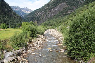
Ticinetto at Chironico |
||
| Data | ||
| Water code | CH : 5162 | |
| location | Switzerland | |
| River system | Po | |
| Drain over | Ticino → Po → Adriatic | |
| source | at Pizzo Penca 46 ° 25 ′ 27 ″ N , 8 ° 44 ′ 42 ″ E |
|
| Source height | approx. 2560 m above sea level M. | |
| muzzle | near Chironico in Ticino coordinates: 46 ° 25 ′ 14 " N , 8 ° 51 ′ 29" E ; CH1903: 709 126 / 142022 46 ° 25 '14 " N , 8 ° 51' 29" O |
|
| Mouth height | 450 m above sea level M. | |
| Height difference | approx. 2110 m | |
| Bottom slope | approx. 19% | |
| length | 10.9 km | |
| Catchment area | 29.1 km² | |
| Discharge at the mouth of the A Eo : 29.1 km² |
MQ Mq |
1.51 m³ / s 51.9 l / (s km²) |
| Left tributaries | Riale di Sasso Rosso | |
| Right tributaries | Ri Laghetto | |
| Communities | Faido , Giornico | |
The Ticinetto ( little Ticino ) is an approximately 11 kilometer long right tributary of the Ticino in the Swiss canton of Ticino . It drains the Val Chironico into the Leventina and flows through the municipalities of Faido and Giornico .
course
The Ticinetto rises at around 2560 m above sea level. M. on the southeast slope of Pizzo Penca a little below the Passo Sovèltra , which leads into Val di Prato , in the municipality of Faido. Directly after the source, it flows through a small mountain lake, which it leaves at its eastern end. It flows briefly to the east, but then turns south, only a little later to bottom the valley at around 2020 m above sea level. To reach M. The outflow of the mountain lake Bola Rossa flows from the right , before it turns to the southeast. It passes the Alp Anzòn and takes in countless short streams, including the Ri di Vedlè , which flows in from the left , whose headwaters extend over the southern slope of the Pizzo Forno .
From the right follows the Ri Laghetto , which drains the mountain lake Laghetto . The Ticinetto is now bordered by dense forests, only around the Alps Valle and Nalpes are cleared areas. He reaches the village of Chironico, where there is a small reservoir. Immediately afterwards, the Ticinetto falls into the Leventina and briefly forms the municipal boundary between Faido and Giornico. Finally the Ticinetto flows out at 450 m above sea level. M. directly below the Biaschina viaduct from the right into Ticino.
Individual evidence
- ↑ a b c Geoserver of the Swiss Federal Administration ( information )
- ↑ a b Topographical catchment areas of Swiss waters: sub-catchment areas 2 km². Retrieved August 31, 2017 .
