Tlalpujahua
| Tlalpujahua de Rayon | ||
|---|---|---|
|
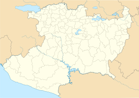
Coordinates: 19 ° 48 ′ N , 100 ° 10 ′ W Tlalpujahua de Rayón on the map of Michoacán
|
||
| Basic data | ||
| Country | Mexico | |
| State | Michoacan | |
| Municipio | Tlalpujahua | |
| City foundation | 1560 | |
| Residents | 3530 (2010) | |
| Detailed data | ||
| height | 2580 m | |
| Website | ||
| Tlalpujahua - Iglesia de San Pedro y San Pablo | ||
| Tlalpujahua - Iglesia de San Pedro y San Pablo (crossing dome) | ||
Tlalpujahua ( Nahuatl : "spongy land") or Tlalpujahua de Rayón is a small town with about 3,500 and the capital of a municipality ( municipio ) with about 27,000 inhabitants in the state of Michoacán in Mexico . The place is one of the charming and culturally significant Pueblos Mágicos .
location
Tlalpujahua is located in the west of the colonial highlands of Mexico at an altitude of approx. 2580 meters above sea level. d. M. about 180 kilometers (driving distance) northwest of Mexico City or about 140 kilometers east of the city of Morelia . The place is under the climatic influence of the Sierra Volcánica Transversal .
Population and economy
Only about 50 inhabitants of the municipality speak Purépecha ; they mostly live in the rural villages. From 1603 until a serious accident on May 27, 1937, in which a third of the city was buried in a landslide, there was a gold mine nearby. Corn , cucumbers , tomatoes , beans and avocados are grown on the fertile soils in the vicinity of the village ; animal husbandry also plays an important role. Tourism is still in the development stage. The city is known in large parts of Mexico for the production of Christmas tree decorations that began in the 1960s .
history
The area was the original tribal area of the Mazahua Indians; the Purépecha immigrated around 1460. At the end of the 15th century, the Aztecs took over power here under their ruler Axayacatl , which then passed into the hands of the Spanish conquerors in the 1520s and 1530s , who revived the mining industry at the beginning of the 17th century. At the beginning of the 18th century, a fire destroyed the place and its churches; the new parish church was built around the middle of the 18th century in late baroque styles. After the independence of Mexico (1821) a city council was established; ten years later the place received city rights and in 1859 the name of the city was supplemented by the name of the independence fighter Ignacio López Rayón .
Attractions
- The streets of today's city are laid out according to a rectangular plan; some cobbled streets still convey a little of the former colonial flair.
- The town hall ( Palacio Municipal ) is located at the Plaza Principal - an elongated and rather unadorned, but nevertheless impressive building from the 16th century, the ground floor of which is opened by numerous arches .
- Not far from there is the one-tower Iglesia de San Pedro y San Pablo (also known as Santuario de Nuestra Señora del Carmen ) from the mid-18th century, whose richly designed late baroque facade reveals influences of the Churrigueresque style . The single nave nave of the church is vaulted and richly adorned with ornamental decor from the 19th century; The highlights are the illuminated crossing dome , which is elevated by a lantern, and the main altar.
- Another church building worth seeing in the town center is the Iglesia de la Señora de Guadalupe , which was also built in the 18th century.
Festivals
Festive events take place throughout the year, at which disguised dancers ( chinelos ) and local music groups ( bandas ) show their skills.
sons and daughters of the town
- Ignacio López Rayón (1773–1832), independence fighter
- Cenobio Paniagua (1821-1882), composer
- Leopoldo Martínez (* 1943), marksman
- Carlos Esquivel (* 1982), football player
Web links
Individual evidence
- ↑ Leopoldo Martínez in the database of Sports-Reference (English)


