Tom (Seja)
|
Tom Томь |
||
|
|
||
| Data | ||
| Water code | RU : 20030400412118100040326 | |
| location | Amur Oblast ( Russia ) | |
| River system | Amur | |
| Drain over | Seja → Amur → Tatar Sound | |
| source |
Turana Mountains 51 ° 16 ′ 9 ″ N , 131 ° 10 ′ 1 ″ E |
|
| muzzle | in the Seja coordinates: 51 ° 1 '7 " N , 127 ° 53' 14" E 51 ° 1 '7 " N , 127 ° 53' 14" E
|
|
| length | 433 km | |
| Catchment area | 16,000 km² | |
| Discharge at the gauge near the mouth |
MQ |
103 m³ / s |
| Medium-sized cities | Belogorsk | |
|
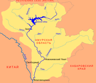
Location of Tom (Томь) in the catchment area of the Seja |
||
The Tom ( Russian Томь ) is a left tributary of the Seja in the Amur Oblast in the Far East of Russia .
The Tom rises on the western flank of the Turana Mountains . It flows in a westerly direction through the Seja-Bureja plain . The river flows through the city of Belogorsk and flows into the lower reaches of the Seja. The tom has a length of 433 km. Its catchment area covers 16,000 km². The river floods every year between May and October . The mean discharge (MQ) near the mouth is 103 m³ / s. The river is ice-covered between late October and early May.
