
Upper sacred walls
| Upper sacred walls | ||
|---|---|---|
 North eruptions of the Upper Gottesackerwände |
||
| height | 2033 m | |
| location | Bavaria , Germany | |
| Mountains | Northwestern Walsertal Mountains , Allgäu Alps | |
| Dominance | 2.1 km → Hoher Ifen | |
| Notch height | 198 m ↓ saddle at Gottesackeralpe | |
| Coordinates | 47 ° 22 '35 " N , 10 ° 7' 0" E | |
|
||
| rock | Schrattenkalk ( Helvetic chalk ) | |
| First ascent | by locals | |

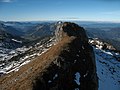
The Oberen Gottesackerwände are a mountain in the Allgäu Alps with the altitude points 2033 m as the west summit and 2016 m as the east summit, the so-called Toreck .
Location and surroundings
The step of the upper Gottesackerwände runs over four kilometers in width almost in an east-west direction and closes off the Gottesacker plateau to the north. Attached to the west are the subordinate summits of Roßkopf ( 1985 m ) and Hirscheck ( 1922 m ). In the further course, the upper Gottesackerwände curve northwards over the Moravia height ( 1703 m ) into the Rubach valley . The main summit and east summit are separated by the Torkopfscharte ( 1968 m ). To the north of the Toreck, the Torkopf ( 1930 m ) rises up ahead. The dividing Windecksattel ( 1751 m ) is located between the Upper and Lower Gottesackewalls in the north . In the south, the Gottesacker plateau is followed by the Hohen Ifens massif with another wall step. Therefore the massif of the Hohen Ifens and the Gottesacker plateau together with the Gottesacker walls are among the strangest mountain ranges in the Alps.
Origin of name
A Wolfegger archive describes a church wall in 1693 ... Under Gotsackher wall . In 1783, Blasius Huebers Vorarlberg map mentions a church B and 1797 in sheet 105 of Schmitt's map a Gotsacker . It was named after the karst area to the south , the Gottesacker plateau, with Gottesacker meaning cemetery . The reason for the name could have been the loneliness of the plateau.
Ascent
There is no marked path to the Upper Gottesackerwände. The ridge height is not difficult with existing surefootedness be reached by the Torkopfscharte.
A popular ski tour leads from the Mahdtalhaus to the Toreck . In the 1990s, the departure through the Mahdtal was closed at the instigation of hunting . Mountaineering associations have reached the opening of a descent road through a forest zone to the Mahdtalhaus, which, however, often gaps and is difficult to drive on. This route was marked in an environmentally friendly way as part of the ski mountaineering project .
photos

Area overview from the south

Wall steps of the lower and upper walls
Main summit

Roßkopf and Hirscheck


Web links
Individual evidence
- ↑ a b Bavarian Surveying Administration : BayernViewer 2.0 . Retrieved November 26, 2010.
- ↑ Dieter Seibert: Alpine Club Guide alpine - Allgäu Alps and Ammergau Alps . 17th edition. Bergverlag Rother, Munich 2008, ISBN 978-3-7633-1126-2 (p. 165 ff).
- ^ Thaddäus Steiner : Allgäu mountain names . 2nd Edition. Kunstverlag Josef Fink, Lindenberg 2008, ISBN 978-3-8987-0389-5 (p. 66).
- ↑ Ernst Zettler, Heinz Groth: Alpine Club Guide - Allgäu Alps . 12th, completely revised edition. Bergverlag Rudolf Rother , Munich 1985, ISBN 3-7633-1111-4 (p. 513).
- ^ Kristian Rath: Ski touring and ski mountaineering Allgäu . Panico Alpinverlag, Köngen 2009 (p. 38), ISBN 3-926807-73-3 .