Torrenthorn
| Torrenthorn | ||
|---|---|---|
|
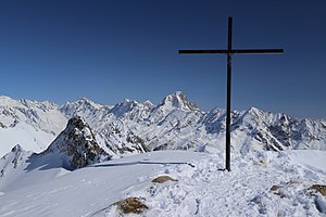
Torrenthorn summit, view to the east over Lötschental, Bietschhorn and Aletschhorn |
||
| height | 2997 m above sea level M. | |
| location | Valais , Switzerland | |
| Mountains | Bernese Alps | |
| Dominance | 1.6 km → Majinghorn | |
| Notch height | 101 m ↓ unnamed notch | |
| Coordinates | 618 484 / 136265 | |
|
|
||
| Normal way | Over the northwest rib to the western fore summit (P. 2889 m), then over the broad ridge to the main summit (T2) | |
The Torrenthorn is 2997 m above sea level. M. high summit in the western Bernese Alps above Leukerbad .
location
The Torrenthorn forms the southwestern end of the mountain range which, starting from the Balmhorn via the Gitzifurgga , the Ferdenrothorn and the Majinghorn , limits the upper Dala valley to the southeast. In the east lies the Lötschental .
Due to its advanced position, the summit offers a far-reaching panorama over the Bernese and Valais Alps and the Rhone Valley to Mont Blanc .
Alpinism
The summit of the Torrenthorn is relatively easy to reach from the Rinderhütte cable car station above Leukerbad, 600 meters below the summit . In summer the ascent takes place via a steep mountain hiking trail (level of difficulty T2 ). In winter, the summit can be climbed on skis or snowshoes (difficulty level L or WT3 ).
Web links
- Torrenthorn on the ETHorama platform

