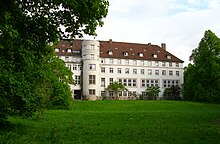
Trillke-Gut
The Trillke-Gut was the old Hildesheimer Stadtgut and from 1928 to 1994 a country school for women . It is located on Steinbergstraße between Berghölzchen and Steinberg am Trillkebach and the forest spring .
history
In 1928, the Hanover Chamber of Agriculture built a large new building on the site of the old Hildesheim city estate, in which an " economic women's school " was set up. For first 60 students ( "Maiden") Abiturientinnenkurse and training seminars were offered to household studies teacher and utility apprentice to. From 1928 to 1976 it was owned by the Hanover Chamber of Agriculture, and from 1976 by the Hildesheim district . It had been a member of the Reifensteiner Verband since around 1932.
From 1933 the school was from NS - Reich managed. In 1936, teacher training was transferred to the universities and was discontinued. In the second half of the 1930s, German Jews were also prepared in the buildings for their emigration to Palestine . After the outbreak of World War II , the "Trillke-Gut" became a military hospital . The women's school was relocated and from 1940 onwards it was operated in "Haus Harderode" near Hameln .
In the post-war period, the buildings were under Dr. Paul Troch (1887–1953) used as a lung sanatorium until 1958 and contained murals by Charles Crodel created around 1950 .
Then the women's school returned to the “Trillke Gut” as a “ technical school for rural housekeeping”. In 1975 it was merged with the Michel School . In 1994 the school was closed due to a lack of pupils.
The city of Hildesheim bought the school building and in 1995 set up a student dormitory in parts of the main building . In 1998, part of the property had to be sold as building land. At the end of 1999 the remaining land and the buildings were sold to a residents' cooperative, which has since used the Trillke-Gut for alternative living and working and has expanded it into a nationally known cultural site.
cooperative
The Trillke Cooperative provides the organizational framework for the residential and cultural project for around 50 to 60 adults and children. Decisions are made in regular meetings on a grassroots basis. In the various living groups, working groups and the house plenary, diverse cultures and a self-reliant coexistence, learning and working develop.
society
In addition to the Trillke cooperative, the registered Trillke association offers a framework for cultural life. In addition to art and cultural projects, readings, concerts, theater performances and lectures, it is also a networking point for interested artists and musicians, and organizes artistic and political seminars and courses.
Music festival
Since 2005 the Trillke-Gut has hosted the annual world music festival Folk'n'Fusion.
Business enterprise
In addition to communal living and cultural life, the Trillke-Gut also offers the framework for various commercial operations, currently u. a. a music school, recording studio, health and martial arts school.
literature
- Ortrud Wörner-Heil: Women's schools in the country - Reifensteiner Association 1897–1997 . 2nd Edition. Kassel 1997 ( series of publications of the Archives of the German Women's Movement , Vol. 11), ISBN 3-926068-12-4 .
- Henning Bleyl / Sabine Brand (eds.): Trillke-Gut: Faces and History . Moritzberg, Hildesheim 2000, ISBN 978-3-9806093-2-6 .
Web links
- Website of the Trillke Estate
- Website of the Trillke e. V.
- Folk'n'Fusion Festival website
- Film about residents and activities (2007, Diploma Film, HAWK Hildesheim)
- Ursula Meyer / Waltraud Lücke: Economic women's school, later Trillke-Gut rural school in Hildesheim (1928–1994) (with numerous photos; PDF; 6.8 MB)
Individual evidence
- ↑ see also the following: Meyer / Lücke (Weblink)
- ↑ Manfred Overesch : Hildesheim 1945-2000 . Hildesheim 2006, p. 284
- ↑ https://www.wienand-verlag.de/out/media/9783868323801.pdf Leopold-Hoesch-Museum
- ^ Manfred Overesch: Renaissance of a cultural city - Hildesheim after the 2nd World War . Hildesheim 1998, p. 36
- ↑ Hildesheimer Jahrbuch für Stadt und Stift Hildesheim 67 (1996), p. 470 u. 481; Manfred Overesch: Hildesheim 1945-2000 . Hildesheim 2006, p. 287
Coordinates: 52 ° 8 ′ 26.4 " N , 9 ° 55 ′ 56.7" E


