Chermassan
|
Tschermassan Чермасан |
||
|
|
||
| Data | ||
| Water code | RU : 10010201512111100025170 | |
| location | Bashkortostan ( Russia ) | |
| River system | Volga | |
| Drain over | Belaya → Kama → Volga → Caspian Sea | |
| source |
Bugulma-Belebeier Heights 54 ° 13 ′ 4 ″ N , 54 ° 26 ′ 45 ″ E |
|
| muzzle | in the Belaja coordinates: 55 ° 10 ′ 21 ″ N , 55 ° 18 ′ 18 ″ E 55 ° 10 ′ 21 ″ N , 55 ° 18 ′ 18 ″ E
|
|
| length | 186 km | |
| Catchment area | 3970 km² | |
| Drain |
MQ |
10 m³ / s |
| Left tributaries | Idjasch, Sarysch | |
|
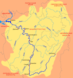
Location of the Tschermassan (Чермасан) in the catchment area of the Belaya |
||
The Tschermassan ( Russian Чермасан ) is a left tributary of the Belaja in the autonomous republic of Bashkortostan in the European part of Russia .
The river has its source in the Bugulma-Belebeier heights in the southwest of Bashkortostan. It flows in a north-northeast direction to the Belaja. The Tschermassan has a length of 186 km. It drains an area of 3970 km². The mean discharge of the Tschermassan is 10 m³ / s. The river is ice-covered between November and April.
Individual evidence
- ↑ a b c d e Article Tschermassan in the Great Soviet Encyclopedia (BSE) , 3rd edition 1969–1978 (Russian)
- ↑ a b Tschermassan in the State Water Register of the Russian Federation (Russian)
