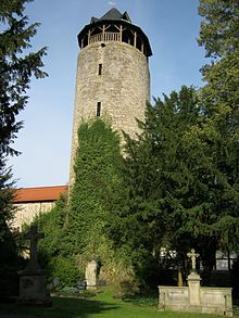
Tylene Tower
The Tylenturm of Korbach in Waldeck-Frankenberg in North Hesse is a medieval defense tower of the city wall . It dates from the late 13th or early 14th century, making it one of the oldest buildings in the city. With a total height of around 31 meters, today's observation tower is one of Korbach's landmarks .
history
middle Ages
The Tylenturm (also Thylen tower or Thülenturm) is named after the noble family von Thulen (also Thulen, Thylen or Tylen), whose name comes from the seat of the same name, Thülen near Brilon in Westphalia . The family had had a castle estate in Korbach by the tower since the 14th century at the latest and was based in the town until the beginning of the 16th century.
The Tylenturm is part of the city wall, which was built in the middle of the 13th century. The thickness of its masonry, its semicircular floor plan and the interior space that is only accessible from the wall make it likely that the tower was also built from this time on. The Tylenturm has only been proven in Korbach since the early 14th century. This means that it is still older than the two Gothic hall churches St. Kilian (from 1335) and St. Nikolai (from 1359).
Modern times
Although Korbach was badly damaged in the Thirty Years' War and in 1664 by a large city fire , the Tylenturm survived the time largely unscathed. From 1733 the first floor of the tower was used as a dungeon for prisoners sentenced to death . In the course of the 19th century, however, it fell into disrepair and was renovated again around 1900. During the Second World War the ground floor was used as an air raid shelter and later as a storage room.
In 1996 the Tylenturm and the adjoining city wall were completely renovated. The occasion was the Hessentag taking place in Korbach a year later . The battlement was reconstructed on the wall and a staircase was created in the tower so that the Tylenturm can be climbed again and used as a lookout tower. In addition, a tower helmet was put on the tower crown again .
Appearance
The Tylenturm has a semicircular floor plan, with the round side facing the outside of the city wall. With the viewing platform under the tower spire, it has a total of six floors . The walls were built from massive, wide- jointed limestone blocks and are more than a meter thick in the lower part.
The ground floor with a barrel vault was originally only accessible with ladders via a high entrance on the city side and previously served as a dungeon . During the Second World War, an entrance was also created on the ground floor so that the ground floor could be used as an air raid shelter.
The second floor lies at a height of about 7.5 m on the battlements of the city wall and can be entered from here on both sides of the tower through round arches with lattice doors. The second and third tower floors have a large, ogival opening on the city side . On the fourth and fifth floors, several loopholes are visible on the outside, but also on the city side . Above the fifth floor there is a viewing platform at a height of around 25 m, which in turn is crowned by the slate-covered tower spire. On the southwest side of the platform, an approximately 1 m high wooden pedestal is attached to improve the view, which extends over the massive outer wall. Overall, the tower is about 31 m high.
On the ascent to the tower, which is only possible as part of a guided tour, a total of 125 steps must be overcome via the external staircase to the battlement and the wooden staircase running in the tower.
The Tylenturm stands on the city wall between the street “Im Sack” and the Totenhagen green area , Korbach's oldest cemetery . This was laid out in front of the city wall in 1588, was used for burials until 2009 and is part of the green belt ring that leads around the city center.
See also
literature
- Hans Osterhold: My city. Korbach buildings tell the history of the city. 4th edition. Korbach 2011.
Web links
References and comments
- ↑ a b c d e According to privately conducted measurements and explorations
- ↑ Photo of the information board on the city wall next to the tower, on commons.wikimedia.org
Coordinates: 51 ° 16 ′ 17.9 ″ N , 8 ° 52 ′ 7 ″ E


