Uda (Pacific)
|
Uda Уда, Ud |
||
|
|
||
| Data | ||
| Water code | RU : 20020000112119000159178 | |
| location | Khabarovsk region ( Russia ) | |
| River system | Uda | |
| source |
Jagdy Mountains 54 ° 10 ′ 9 ″ N , 130 ° 50 ′ 39 ″ E |
|
| muzzle | in the Uda Bay ( Sea of Okhotsk ) Coordinates: 54 ° 44 ′ 26 " N , 135 ° 18 ′ 5" E 54 ° 44 ′ 26 " N , 135 ° 18 ′ 5" E |
|
| Mouth height |
0 m
|
|
| length | 457 km | |
| Catchment area | 61,300 km² | |
| Drain |
MQ |
510 m³ / s |
| Left tributaries | Chogar , Maja , Dschana , Udychyn | |
| Right tributaries | Shevli , Gerbikan , Galam | |
| Communities | Tschumikan | |
|
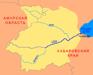
Uda catchment area |
||
The Uda ( Russian Уда , also called Ud ) is a 457 km long river in the Far East of Russia .
It rises in the Khabarovsk region on the northern flank of the Jagdy Mountains and flows in a slightly northeastern direction to the Sea of Okhotsk , a north-western marginal sea of the Pacific. At Tschumikan the Uda flows into the Uda Bay , the westernmost part of the sea. The Shantar Islands are to the east of the mouth of the Udam .
The Uda catchment area covers 61,300 km². Their mean water flow is 510 m³ / s. The river is icy from late October / early November to May.
Salmon spawn in the river .
literature
- G. Gilbo: Sprawotschnik po istorii geografitscheskich naswani na pobereschje SSSR . Ministerstwo oborony Soiusa SSR, Glaw. upr. nawigazii i okeanografii, 1985, p. 356. (Russian)
