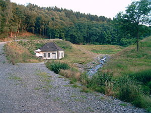
Lower Herbringhauser dam
| Lower Herbringhauser dam | |||||||
|---|---|---|---|---|---|---|---|
|
|||||||
|
|
|||||||
| Coordinates | 51 ° 15 '2 " N , 7 ° 16' 17" E | ||||||
| Data on the structure | |||||||
| Construction time: | -1927 | ||||||
| Height above valley floor: | 19.5 m | ||||||
| Height above foundation level : | 20 m | ||||||
| Building volume: | 29,000 m³ | ||||||
| Crown length: | 103 m | ||||||
| Data on the reservoir | |||||||
| Altitude (at congestion destination ) | 197.37 m | ||||||
| Water surface | 4 ha | ||||||
| Storage space | 0.18 million m³ | ||||||
| Catchment area | 9.2 km² | ||||||
The lower Herbringhauser dam was a small dam in the urban area of Wuppertal . It was south of Langerfeld on the Herbringhauser Bach , shortly before it flows into the Wupper . It was located below the somewhat larger Upper Herbringhauser Dam . In 2006 it was partially canceled due to concerns about stability .
purpose
The dam was built as an additional water reservoir to the Upper Herbringhauser dam in 1926/27 and was put into operation in 1928. It was supposed to store drinking water for the city of Wuppertal, for which there was no free capacity in the Herbringhauser dam, and to pump it back into the upper dam. The pump house below the dam is still preserved and is a listed building. The hamlet of Hilgershammer , consisting of several residential buildings, had to give way for their construction . The dam was owned by the Wuppertal public utilities . Until 2006, the listed dam was primarily part of the local nature reserve . The Herbringhauser Tal in the area of the former reservoir is now to develop into a stream floodplain again.
The dam
The barrier structure was a stone embankment dam with a concrete core. The Wuppertal public utilities had been striving for the planned dismantling of the dam since 1998, as they considered the necessary renovation to be uneconomical and no longer needed for the drinking water supply. By order of the district government in Düsseldorf , the listed dam was demolished in 2006 over a width of 80 m, but without a plan approval procedure . The reason was doubts about the stability, as the dam no longer complied with the standards for flood protection , which make provision for a flood that statistically only occurs every 5000 years. Monument and nature protection lagged behind these requirements. As a result of the demolition, several hiking trails leading over the top of the dam , including the Wuppertaler Rundweg , had to be relocated.
See also
Web links
- Lower Herbringhauser dam. In: Structurae
- Dams directory NRW (PDF; 122 kB)
- Dams in North Rhine-Westphalia; State Environment Agency NRW
- Statement by the regional community for nature conservation and the environment on the abandonment of the dam
Individual evidence
- ↑ Brochure of the Wuppertaler Stadtwerke, for the outline p. 28f ( Memento of September 27, 2007 in the Internet Archive )


