
Upałty
| Upałty | ||
|---|---|---|
 |
||
| Waters | Mamry | |
| Geographical location | 54 ° 10 ′ 26 " N , 21 ° 40 ′ 19" E | |
|
||
| length | 1.7 km | |
| width | 800 m | |
| surface | 67 ha | |
| Residents | uninhabited | |
 |
||

Upałty ( German Upalten , formerly Werder Upalten or Steinortscher Werder ) is a publicly inaccessible island in the Mauersee ( Polish Jezioro Mamry ) near the Polish town of Węgorzewo ( German Angerburg ). With a size of 67 hectares , it is the largest island in the Masurian Lake District .
The banks of the island are lined with a belt of reed beds . The island is densely forested with stands of oak , linden , elm , hornbeam , willow and hazelnut . The island is part of the nature reserve Rezerwat przyrody Wyspy na Jeziorach Mamry i Kisajno ("Nature reserve islands in the Wall and Kissain Lakes"). The southern part in particular is used as a breeding ground for various species of songbirds and sea eagles .
From the middle of the 16th century to the middle of the 20th century, the island was owned by the Lehndorff family . In the northern part there were some buildings, including the Inselkrug, an excursion restaurant. The island was also used for agriculture. Today only foundation walls are evidence of the buildings. Today there are still two memorial stones. One on the west bank commemorates August Quednau , who died on the Mauersee.
The tiny side island Mała Kępa ( German pyramid island , literally “small Werder ” ) is just 200 meters from its southern tip . The German name came from a 40 foot high pyramid that Ernst von Lehndorff built in 1793 in honor of Count Henckel von Donnersmarck . Over the years this pyramid was worn away by the waves.
Upalten was a residential area of Groß Steinort until 1945 (1928 to 1945: Steinort, in Polish Sztynort ). She was office Village in the district Angerburg in Administrative district Gumbinnen the Prussian province of East Prussia . In 1867, four residents were registered in Upalten, in 1885 there were nine and in 1905 eight. Ecclesiastically they belonged to the Evangelical Church Engelstein ( Polish: Węgielsztyn ) and the Catholic parish of the Good Shepherd in Angerburg .
Today the island is uninhabited. It is located in the area of the urban and rural municipality Węgorzewo (Angerburg) .

Lush tree vegetation on Upalten
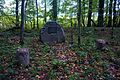
Gravestone of the teacher August Quednau on Upalten
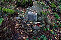
Seaman's memorial


Individual evidence
- ↑ a b Measurement table sheet Groß Steinort , 1: 25,000, 1938
- ^ Max Pollux Toeppen : History of Masuria . Bertling, Danzig 1870, p. 280 ( digitized version )
- ↑ Bernd Braumüller, Erich Pfeiffer: Heimat am Mauersee, an illustrated book about the district of Angerburg / East Prussia . Self-published by the Kreisgemeinschaft Angerburg, Rotenburg (Wümme) 1977, p. 20 ff.
- ^ History of the island of Upalten (English). Online reference. Accessed January 16, 2014
- ^ Rolf Jehke, Steinort District
- ↑ Upalten at wiki-de