Upland (Indiana)
| Upland | |
|---|---|
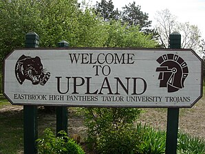
 Welcome sign |
|
| Location of Upland in Grant County (left) and Indiana (right) | |
| Basic data | |
| Foundation : | 1860 |
| State : | United States |
| State : | Indiana |
| County : | Grant County (Indiana) |
| Coordinates : | 40 ° 28 ′ N , 85 ° 30 ′ W |
| Time zone : | Eastern ( UTC − 5 / −4 ) |
| Residents : | 3,845 (as of 2010) |
| Population density : | 472.9 inhabitants per km 2 |
| Area : | 8.16 km 2 (approx. 3 mi 2 ) of which 8.13 km 2 (approx. 3 mi 2 ) is land |
| Height : | 285 m |
| Postal code : | 46989 |
| Area code : | +1 765 |
| FIPS : | 18-77966 |
| GNIS ID : | 0445158 |
| Website : | upland.in.gov |
Upland is a city in Grant County in the US state of Indiana with around 3,800 inhabitants (as of 2010). The city is known as the home of Taylor University . The urban area has a size of approximately 8 square kilometers.
history
Most of what is now the urban area was bought by speculator John Oswalt in the 1830s . He hoped that a canal could be built through the area to connect Indianapolis and Fort Wayne . The town itself was founded by Jacob Bugher in the late 1860s. The town's name refers to the fact that it was believed that the city was the highest point on the railway line between Columbus and Chicago . By 1880 the city's population had grown to 150 people.
The Taylor University moved in the summer of 1893, due to financial problems, from Fort Wayne to Upland, where she also received $ 10,000 financial support in addition to 40,000 square meters of land.
location
Upland is between Fort Wayne and Indianapolis, about an hour away. The closest university towns are Muncie and Marion .
Web links
- Internet presence of Upland (English)
Individual evidence
- ^ Taylor University: The First 150 Years by William C. Ringenberg. Upland: Taylor University Press, 1996.
