Muncie (Indiana)
| Muncie | ||
|---|---|---|
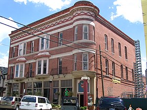
 The Francis T. Roots Building (1890), listed as historical by the NRHP |
||
| Location in Indiana | ||
|
|
||
| Basic data | ||
| Foundation : | 1827 | |
| State : | United States | |
| State : | Indiana | |
| County : | Delaware County | |
| Coordinates : | 40 ° 12 ′ N , 85 ° 23 ′ W | |
| Time zone : | Eastern ( UTC − 5 / −4 ) | |
|
Inhabitants : - Metropolitan Area : |
69,010 (as of 2016) 115,603 (as of 2016) |
|
| Population density : | 1,102.4 inhabitants per km 2 | |
| Area : | 62.7 km 2 (approx. 24 mi 2 ) of which 62.6 km 2 (approx. 24 mi 2 ) is land |
|
| Height : | 284 m | |
| Postcodes : | 47302-47308 | |
| Area code : | +1 765 | |
| FIPS : | 18-51876 | |
| GNIS ID : | 0439878 | |
| Website : | www.cityofmuncie.com | |
| Mayor : | Dennis Tyler | |
Muncie (pronounced "mʌnsi") is a city with 70,085 inhabitants (2010) in the US state of Indiana . It is located in the Indianapolis metropolitan area , 81 km northeast of that city and 106 km southwest of Fort Wayne , 112 km northwest of the city of Dayton , 72 km southeast of the city of Kokomo and 265 km southeast of the city of Chicago . Muncie is part of Delaware County .
economy
Muncie was also an important manufacturing base for several companies in the automotive industry from 1909 to 2007. The Inter-State Automobile Company first settled , to the Ball Automobile Company, which was spun off from it, and from 1920 also the Chevrolet Motor Company . In addition, the battery manufacturer Delco was located here for a few decades .
Population development
| year | Residents¹ |
|---|---|
| 1980 | 77.216 |
| 1990 | 71,170 |
| 2000 | 67,430 |
| 2010 | 70.085 |
¹ 1980–2010: Census Results
Culture
Minnetrista is a museum and cultural center in Muncie about the history of the seven counties of Middle East Indiana.
Trivia
The comic series Knights of the Dinner Table is essentially set in Muncie.
sons and daughters of the town
- Joseph A. McArdle (1903-1967), politician
- Andy Secrest (1907–1977), jazz trumpeter and cornet player
- Ralph F. Hefferline (1910–1974), Professor of Psychology at Columbia University
- Doc Wheeler (1910-2005), jazz musician
- John Webster Kirklin (1917-2004), cardiac surgeon
- James Edwards (1918–1970), actor
- Jack Beeson (1921-2010), composer
- John McGreevey (1922-2010), screenwriter
- Al Kiger (1932–2013), jazz trumpeter, arranger and composer
- Gene Brewer (born 1937), writer
- William Lawvere (born 1937), mathematician
- Paul Smoker (1941–2016), jazz musician
- John Paul junior (* 1960), racing car driver and drug dealer
- Troy Pierce (* 1970), DJ and music producer
- Bonzi Wells (* 1976), former basketball player
- Ryan Kerrigan (born 1988), American football player
