Delaware County (Indiana)
 Delaware County Courthouse |
|
| administration | |
|---|---|
| US state : | Indiana |
| Administrative headquarters : | Muncie |
| Foundation : | 1827 |
| Demographics | |
| Residents : | 117,671 (2010) |
| Population density : | 115.6 inhabitants / km 2 |
| geography | |
| Total area : | 1025 km² |
| Water surface : | 7 km² |
| map | |
| Website : www.co.delaware.in.us | |
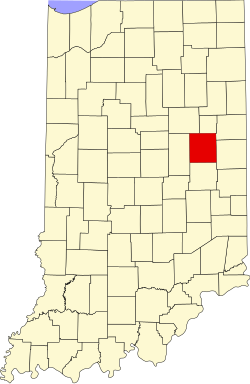
Delaware County is a county in the US state of Indiana in the United States . The seat of the county government is Muncie .
history
Delaware County was established with effect from April 1, 1827 and were prepared in accordance of the Delaware originating Lenni Lenape named who had been resettled there.
43 structures and sites in the county are on the National Register of Historic Places (as of August 31, 2017).
population
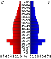
At the 2000 census , the county had 118,769 people and a population density of 117 people per square kilometer.
geography
Madison County has an area of 1025 square kilometers, of which 1018 square kilometers are land and seven square kilometers are covered with water. Water thus covers 0.66 percent of the county's surface.
The neighboring counties starting clockwise from the north are: Blackford Counties , Jay Counties , Randolph Counties , Henry County , Madison Counties , and Grant Counties
| Population development | |||
|---|---|---|---|
| Census | Residents | ± in% | |
| 1820 | 3677 | - | |
| 1830 | 2374 | -35.4% | |
| 1840 | 8843 | 272.5% | |
| 1850 | 10,843 | 22.6% | |
| 1860 | 15,753 | 45.3% | |
| 1870 | 19,030 | 20.8% | |
| 1880 | 22,926 | 20.5% | |
| 1890 | 30.131 | 31.4% | |
| 1900 | 49,624 | 64.7% | |
| 1910 | 51,414 | 3.6% | |
| 1920 | 56,377 | 9.7% | |
| 1930 | 67,270 | 19.3% | |
| 1940 | 74,963 | 11.4% | |
| 1950 | 90.252 | 20.4% | |
| 1960 | 110,938 | 22.9% | |
| 1970 | 129,219 | 16.5% | |
| 1980 | 128,587 | -0.5% | |
| 1990 | 119,659 | -6.9% | |
| 2000 | 118,769 | -0.7% | |
| 2010 | 117,671 | -0.9% | |
| Before 1900
1900–1990 2000 + 2010 |
|||
Places in the county
- Albany
- Andersonville
- Anthony
- Aultshire
- Bethel
- Cammack
- Chesterfield
- Cowan
- Creston
- Cross roads
- Daleville
- Desoto
- Drew
- Eaton
- Gaston
- Gates Corner
- Granville
- Hyde Park
- Irvington
- Janney
- Liberty Corners
- Mayfield
- Medford
- Middletown Park
- Morningside
- Mount Pleasant
- Muncie
- New Burlington
- Oakville
- progress
- Reed station
- Shideler
- Smithfield
- Stockport
- West Muncie
- Wheeling
- Woodland Park
- Yorktown
Individual evidence
- ↑ GNIS-ID: 450347. Retrieved on February 22, 2011 (English).
- ↑ Charles Curry Aiken & Joseph Nathan Kane: The American Counties: Origins of County Names, Dates of Creation, Area, and Population Data, 1950-2010 . 6th edition. Scarecrow Press, Lanham 2013, ISBN 978-0-8108-8762-6 , p. 82.
- ↑ Search mask database in the National Register Information System. National Park Service , accessed September 1, 2017.
- ↑ US Census Bureau - Census of Population and Housing . Retrieved March 15, 2011
- ↑ Extract from Census.gov . Retrieved February 15, 2011
- ↑ Excerpt from census.gov (2000 + 2010) ( Memento of the original from July 9, 2011 on WebCite ) Info: The archive link was inserted automatically and has not yet been checked. Please check the original and archive link according to the instructions and then remove this notice. Retrieved April 2, 2012
Web links
Coordinates: 40 ° 14 ′ N , 85 ° 24 ′ W

