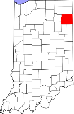
Allen County, Indiana
![Allen County Courthouse in Fort Wayne, listed on NRHP No. 76000031 [1]](https://upload.wikimedia.org/wikipedia/commons/thumb/b/bc/Cortes_del_Condado_de_Allen%2C_Fort_Wayne%2C_Indiana%2C_Estados_Unidos%2C_2012-11-12%2C_DD_03.jpg/298px-Cortes_del_Condado_de_Allen%2C_Fort_Wayne%2C_Indiana%2C_Estados_Unidos%2C_2012-11-12%2C_DD_03.jpg) Allen County Courthouse in Fort Wayne, listed on NRHP No. 76000031 |
|
| administration | |
|---|---|
| US state : | Indiana |
| Administrative headquarters : | Fort Wayne |
| Foundation : | 1824 |
| Demographics | |
| Residents : | 355,329 (2010) |
| Population density : | 208.6 inhabitants / km 2 |
| geography | |
| Total area : | 1710 km² |
| Water surface : | 7 km² |
| map | |
| Website : www.co.allen.in.us | |
Allen County is a county in the state of Indiana in the United States . The county seat is Fort Wayne . The county is named after John Allen , an officer and state senator from Kentucky who was killed in the War of 1812 .
geography
At 1,710 square kilometers, it is the largest county in Indiana. The neighboring counties (starting north, clockwise) are Noble County , DeKalb County , Defiance County ( Ohio ), Paulding County (Ohio), Van Wert County (Ohio), Adams County , Wells County , Huntington County, and Whitley County .
history
|
||||||||||||||||||||||||||||||||||||||||||||||||||||||||||||||||||||||||||||||||||||||||
Allen County has a National Historic Landmark , the Allen County Courthouse in Fort Wayne. A total of 63 buildings and sites in the county are listed on the National Register of Historic Places (as of August 31, 2017).
- Allen County Courthouse
Amish have settled in Allen County since 1852 . The names Graber, Lengacher and Schwartz are often found in the Swiss -German communities. Today the county has approximately 3,200 people in 22 parishes.
Cities in the county
Cities |
Towns
|
Web links
Individual evidence
- ^ Extract from the National Register of Historic Places . Retrieved March 13, 2011
- ↑ GNIS-ID: 450402. Retrieved on February 22, 2011 (English).
- ↑ US Census Bureau - Census of Population and Housing . Retrieved March 15, 2011
- ↑ Extract from Census.gov . Retrieved February 15, 2011
- ↑ Extract from census.gov (2000 + 2010). Accessed April 2, 2012
- ↑ Listing of National Historic Landmarks by State: Indiana . National Park Service , accessed August 31, 2017.
- ↑ Search mask database in the National Register Information System. National Park Service , accessed August 31, 2017.
- ↑ Amish America - The 12 Largest Amish Communities (2017 ), accessed April 30, 2018
Coordinates: 41 ° 5 ′ N , 85 ° 4 ′ W


