Warrick County
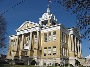
 Warrick County Counrthouse |
|
| administration | |
|---|---|
| US state : | Indiana |
| Administrative headquarters : | Boonville |
| Address of the administrative headquarters: |
County Courthouse 109 W. Main Street Boonville, IN 47601-1513 |
| Foundation : | March 9, 1813 |
| Made up from: | Knox County |
| Area code : | 001 812 |
| Demographics | |
| Residents : | 59,689 (2010) |
| Population density : | 60 inhabitants / km 2 |
| geography | |
| Total area : | 1012 km² |
| Water surface : | 18 km² |
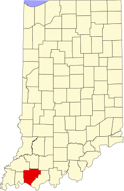
| map | |
| Website : www.warrickcounty.gov | |
The Warrick County is a county in the US state of Indiana . The county seat is Boonville .
geography
The county is located in southwest Indiana on the Ohio River , which forms the border with Kentucky . It has an area of 1,012 square kilometers, of which 18 square kilometers are water. The following counties border Warrick County:
| Gibson County | Pike County | Dubois County |
| Vanderburgh County |

|
Spencer County |
| Henderson County, Kentucky |
Daviess County, Kentucky |
history
Warrick County was formed on March 9, 1813 from parts of Knox County. It was named after Jacob Warrick (1773-1811), an officer who died in the battle of Tippecanoe .
7 buildings and sites in the county are listed on the National Register of Historic Places (as of September 5, 2017).
Demographic data
| growth of population | |||
|---|---|---|---|
| Census | Residents | ± in% | |
| 1820 | 1749 | - | |
| 1830 | 2877 | 64.5% | |
| 1840 | 6321 | 119.7% | |
| 1850 | 8811 | 39.4% | |
| 1860 | 13,261 | 50.5% | |
| 1870 | 17,653 | 33.1% | |
| 1880 | 20,162 | 14.2% | |
| 1890 | 21,161 | 5% | |
| 1900 | 22,329 | 5.5% | |
| 1910 | 21,911 | -1.9% | |
| 1920 | 19,862 | -9.4% | |
| 1930 | 18,230 | -8.2% | |
| 1940 | 19,435 | 6.6% | |
| 1950 | 21,527 | 10.8% | |
| 1960 | 23,577 | 9.5% | |
| 1970 | 27,972 | 18.6% | |
| 1980 | 41,474 | 48.3% | |
| 1990 | 44,920 | 8.3% | |
| 2000 | 52,383 | 16.6% | |
| 2010 | 59,689 | 13.9% | |
| Before 1900 1900–1990 2000 + 2010 | |||

As of the 2010 census , Warrick County had 59,689 people in 22,223 households. The population density was 52.7 inhabitants per square kilometer.
The racial the population was composed of 95.0 percent white, 1.3 percent African American, 0.2 percent Native American, 1.6 percent Asian and other ethnic groups; 1.3 percent were descended from two or more races. Hispanic or Latino of any race was 1.6 percent of the population.
Statistically, 2.53 people lived in each of the 22,223 households.
25.9 percent of the population were under 18 years old, 60.8 percent were between 18 and 64 and 13.3 percent were 65 years or older. 50.7 percent of the population was female.
The median income for a household was 58,436 USD . The per capita income was $ 29,237. 8.0 percent of the population lived below the poverty line.
Places in Warrick County
- other places
- Ash Iron Springs
- Baugh City
- Bullocktown
- Camp Brosend
- center
- Dayville
- De Gonia Springs
- Dickeyville
- Eames
- Eby
- Fisherville
- Folsomville
- Graham Valley
- Greenbrier
- Heilman
- Hemenway
- Hillcrest Terrace
- jockey
- Loafers station
- Millersburg
- New Hope
- Paradise
- Pelzer
- Red Bush
- Rolling acres
- Rustic Hills
- Scalesville
- Selvin
- Stanley
- Stevenson
- Turpin Hill
- Vanada
- Wheatonville
- Yankeetown
Individual evidence
- ↑ GNIS-ID: 450335. Retrieved on February 22, 2011 (English).
- ^ National Association of Counties.Retrieved November 21, 2011
- ↑ Search mask database in the National Register Information System. National Park Service , accessed September 5, 2017.
- ^ US Census Bureau - Census of Population and Housing.Retrieved March 15, 2011
- ↑ Extract from Census.gov . Retrieved February 16, 2011
- ↑ Extract from census.gov (2000 + 2010). Accessed April 2, 2012
- ↑ Extract from the National Register of Historic Places - No. 79000025.Retrieved November 21, 2011
- ↑ Extract from the National Register of Historic Places - No. 78000040.Retrieved November 21, 2011
- ^ US Census Bureau, State & County QuickFacts - Warrick County. Retrieved November 21, 2011
Web links
- US Census Bureau, State & County QuickFacts - Warrick County
- Yahoo Image Search - Warrick County
- www.city-data.com - Warrick County
Coordinates: 38 ° 6 ′ N , 87 ° 16 ′ W

