Carroll County, Indiana
![Carroll County Courthouse in Delphi, listed on NRHP No. 03001317 [1]](https://upload.wikimedia.org/wikipedia/commons/thumb/7/7c/Carrol_County_1916.jpg/298px-Carrol_County_1916.jpg) Carroll County Courthouse, Delphi, listed on NRHP No. 03001317 |
|
| administration | |
|---|---|
| US state : | Indiana |
| Administrative headquarters : | Delphi |
| Address of the administrative headquarters: |
County Courthouse P.O. Box 28 Delphi, IN 46923-0028 |
| Foundation : | January 7, 1826 |
| Made up from: | Original County |
| Area code : | 001 317 |
| Demographics | |
| Residents : | 20,155 (2010) |
| Population density : | 20.9 inhabitants / km 2 |
| geography | |
| Total area : | 971 km² |
| Water surface : | 7 km² |
| map | |
| Website : www.carlnet.org | |
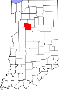
Carroll County is a county in the state of Indiana in the United States . The county seat is Delphi .
geography
The county is located in central northwest Indiana, about 100 km to the west from Illinois and has an area of 971 square kilometers, of which seven square kilometers are water. It is bordered in a clockwise direction by the following counties: Cass County , Howard County , Clinton County , Tippecanoe County, and White Counties .
history
Carroll County was formed as the original Free Territory County on January 7, 1826. It was named after Charles Carroll , a signer of the United States' Declaration of Independence.
21 structures and sites in the county are listed on the National Register of Historic Places (as of August 31, 2017).
Demographic data
| growth of population | |||
|---|---|---|---|
| Census | Residents | ± in% | |
| 1830 | 1611 | - | |
| 1840 | 7819 | 385.4% | |
| 1850 | 11,015 | 40.9% | |
| 1860 | 13,489 | 22.5% | |
| 1870 | 16,152 | 19.7% | |
| 1880 | 18,345 | 13.6% | |
| 1890 | 20,021 | 9.1% | |
| 1900 | 19,953 | -0.3% | |
| 1910 | 17,970 | -9.9% | |
| 1920 | 16,315 | -9.2% | |
| 1930 | 15,049 | -7.8% | |
| 1940 | 15,410 | 2.4% | |
| 1950 | 16,010 | 3.9% | |
| 1960 | 16,934 | 5.8% | |
| 1970 | 17,734 | 4.7% | |
| 1980 | 19,722 | 11.2% | |
| 1990 | 18,809 | -4.6% | |
| 2000 | 20,165 | 7.2% | |
| 2010 | 20,155 | -0% | |
| Before 1900
1900–1990 2000 + 2010 |
|||
According to the 2000 census , Carroll County had 20,165 people in 7,718 households and 5,688 families. The population density was 21 people per square kilometer. The racial the population was composed of 97.65 percent white, 0.20 percent African American, 0.16 percent Native American, 0.06 percent Asian and 1.39 percent from other ethnic groups; 0.54 percent were descended from two or more races. Hispanic or Latino of any race was 2.93 percent of the population.
Of the 7,718 households, 33.2 percent had children under the age of 18 living with them in the household. 63.5 percent were married couples living together, 6.5 percent were single mothers, and 26.3 percent were non-families. 22.8 percent were single households and 10.5 percent had people aged 65 or over. The average household size was 2.59 and the average family size was 3.04.
26.3 percent of the population were under 18 years old, 7.4 percent between 18 and 24, 28.7 percent between 25 and 44 years. 23.6 percent between 45 and 64 and 13.9 percent were 65 years of age or older. The median age was 37 years. For every 100 females there were 99.6 males. For every 100 women aged 18 and over there were 96.8 men.
The median income for a household in the 42,677 USD , and the median income for a family 50,216 USD. Males had a median income of $ 35,348 versus $ 21,385 for females. The per capita income was $ 19,436. 4.3 percent of families and 6.8 percent of the population are below the poverty line.
Places in the county
- Adams Mill
- Breezy Point
- Bringhurst
- Burlington
- Burrows
- C and C Beach
- Camden
- Carrollton
- Cutler
- Deer Creek
- Delphi
- flora
- Gingrich addition
- Lakewood
- Lexington
- Lockport
- Lower Sunset Park
- Ockley
- Owasco
- Patton
- Pittsburg
- Prince William
- Pyrmont
- Radnor
- Rockfield
- Roth Park
- Sandy Beach
- Scarlet Oaks
- Sharon
- Sleeth
- Terrace Bay
- Upper Sunset Park
- Walnut Gardens
- Wheeling
See also
Individual evidence
- ^ Extract from the National Register of Historic Places . Retrieved March 13, 2011
- ↑ GNIS-ID: 450406. Retrieved on February 22, 2011 (English).
- ↑ Search mask database in the National Register Information System. National Park Service , accessed August 31, 2017.
- ↑ US Census Bureau - Census of Population and Housing . Retrieved March 15, 2011
- ↑ Extract from Census.gov . Retrieved February 15, 2011
- ↑ Extract from census.gov (2000 + 2010). Accessed April 2, 2012
- ^ Carroll County, Indiana , 2000 census data sheet at factfinder.census.gov .
Web links
Coordinates: 40 ° 35 ′ N , 86 ° 34 ′ W

