Switzerland County
 Switzerland County Courthouse |
|
| administration | |
|---|---|
| US state : | Indiana |
| Administrative headquarters : | Vevay |
| Foundation : | 1814 |
| Demographics | |
| Residents : | 10,613 (2010) |
| Population density : | 18.5 inhabitants / km 2 |
| geography | |
| Total area : | 579 km² |
| Water surface : | 6 km² |
| map | |
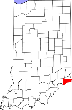
Switzerland County is a county in the southeast of the US state Indiana with the administrative seat in Vevay .
geography
The county covers an area of 579 km² , 573 km² of land and 6 km² of water. This results in a water surface share of around 1.05%.
The Ohio River forms the entire border with Kentucky to the south and east . In addition to the Ohio, the Indian Creek and the Log Lick Creek flow through the county .
Adjacent counties
- Ohio County (Indiana) to the north
- Gallatin County, Kentucky to the east
- Carroll County, Kentucky to the south
- Jefferson County, Indiana to the west
- Ripley County, Indiana, in the northwest
history
The county was founded in 1814. It was named after the homeland of many European settlers in this region, Switzerland . The founder of the main town Vevay was a winegrower from the canton of Vaud , who named the new town after his old hometown, the town of Vevey . Industrial viticulture also helped give the county the nickname of the Rhineland of America .
8 buildings and sites in the county are listed on the National Register of Historic Places (as of September 4, 2017).
Demographic data
| Population development | |||
|---|---|---|---|
| Census | Residents | ± in% | |
| 1820 | 3934 | - | |
| 1830 | 7028 | 78.6% | |
| 1840 | 9920 | 41.1% | |
| 1850 | 12,932 | 30.4% | |
| 1860 | 12,698 | -1.8% | |
| 1870 | 12.134 | -4.4% | |
| 1880 | 13,336 | 9.9% | |
| 1890 | 12,514 | -6.2% | |
| 1900 | 11,840 | -5.4% | |
| 1910 | 9914 | -16.3% | |
| 1920 | 9311 | -6.1% | |
| 1930 | 8432 | -9.4% | |
| 1940 | 8167 | -3.1% | |
| 1950 | 7599 | -7% | |
| 1960 | 7092 | -6.7% | |
| 1970 | 6306 | -11.1% | |
| 1980 | 7153 | 13.4% | |
| 1990 | 7738 | 8.2% | |
| 2000 | 9065 | 17.1% | |
| 2010 | 10,613 | 17.1% | |
| Before 1900
1900–1990 2000 + 2010 |
|||

According to the 2000 US Census , the county had 9,065 people. The population density was 16 people per square kilometer. 4,226 residential units were recorded. 98.78 percent of the population were European, 0.23 percent African American, 0.15 percent Indigenous American, 0.09 percent Asian, 0.01 percent from the Pacific, 0.86 percent Latin American, 0.74 percent other, as well People of mixed ethnicity.
The median income in the county was $ 37,092. 13.9 percent of the population lived below the poverty line .
Places in Switzerland County
Census-designated places (CDP)
Individual evidence
- ↑ GNIS-ID: 450392. Retrieved on February 22, 2011 (English).
- ↑ Search mask database in the National Register Information System. National Park Service , accessed September 4, 2017.
- ↑ US Census Bureau - Census of Population and Housing . Retrieved March 15, 2011
- ↑ Extract from Census.gov . Retrieved February 16, 2011
- ↑ Extract from census.gov (2000 + 2010). Accessed April 2, 2012
- ↑ Switzerland County, Indiana , data sheet with the results of the 2000 census at factfinder.census.gov .
Web links
Coordinates: 38 ° 49 ′ N , 85 ° 2 ′ W
