Jackson County, Indiana
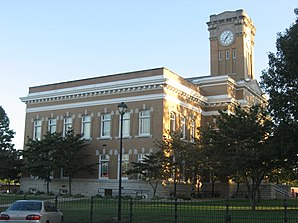
 The Jackson County Courthouse in Brownstown, listed on the NRHP |
|
| administration | |
|---|---|
| US state : | Indiana |
| Administrative headquarters : | Brownstown |
| Foundation : | 1816 |
| Demographics | |
| Residents : | 42,376 (2010) |
| Population density : | 32.1 inhabitants / km 2 |
| geography | |
| Total area : | 1331 km² |
| Water surface : | 12 km² |
| map | |
Jackson County is a county in the state of Indiana in the United States . The county seat is Brownstown .
geography
Jackson County is located in south central Indiana and has a size of 1,331 square kilometers, of which twelve square kilometers are water surface. The neighboring counties (starting in the north, clockwise) are: Brown County , Bartholomew County , Jennings County , Scott County , Washington County , Lawrence County, and Monroe County .
history
Jackson County was formed in 1816. It was named after Andrew Jackson , who defeated the British in the British-American War in 1812 and in the Battle of New Orleans in 1815 . He later became President of the United States and signed the Indian Removal Act on May 28, 1830 .
In the county, the first detectable railroad robbery on a moving train took place by the Reno Gang on October 8, 1866. The gang stole around $ 10,000 from a train on the Ohio and Mississippi Railway .
In 1875 the Medora Covered Bridge was built. At that time it was the longest wooden bridge standing on three limestone pillars at 132 meters. Closed to vehicle traffic in 1972, but remained open to pedestrians. Listed in the NRHP .
A total of 17 buildings and sites in the county are registered in the National Register of Historic Places (as of September 2, 2017).
| growth of population | |||
|---|---|---|---|
| Census | Residents | ± in% | |
| 1820 | 4010 | - | |
| 1830 | 4870 | 21.4% | |
| 1840 | 8961 | 84% | |
| 1850 | 11,047 | 23.3% | |
| 1860 | 16,286 | 47.4% | |
| 1870 | 18,974 | 16.5% | |
| 1880 | 23,050 | 21.5% | |
| 1890 | 24,139 | 4.7% | |
| 1900 | 26,633 | 10.3% | |
| 1910 | 24,727 | -7.2% | |
| 1920 | 24,228 | -2% | |
| 1930 | 23,731 | -2.1% | |
| 1940 | 26,612 | 12.1% | |
| 1950 | 28,237 | 6.1% | |
| 1960 | 30,556 | 8.2% | |
| 1970 | 33,187 | 8.6% | |
| 1980 | 36,523 | 10.1% | |
| 1990 | 37,730 | 3.3% | |
| 2000 | 41,335 | 9.6% | |
| 2010 | 42,376 | 2.5% | |
| Before 1900
1900–1990 2000 + 2010 |
|||
Places in the county
- Acme
- Soon knobs
- Bobtown
- Brownstown
- Chestnut Ridge
- Clear Spring
- Cortland
- Crothersville
- Dudleytown
- Ewing
- Fleming
- Freetown
- Hangman Crossing
- Houston
- Kriete Corner
- Short
- Little Acre
- Maumee
- Medora
- New Elizabethtown
- New Farmington
- Norman
- Reddington
- Retreat
- Rockford
- Seymour
- Shields
- Sparksville
- Spraytown
- Sunset Parkway
- Surprise
- Tampico
- Uniontown
- Vallonia
- Weddleville
- Wegan
Individual evidence
- ↑ GNIS-ID: 451678. Retrieved on February 22, 2011 (English).
- ↑ Search mask database in the National Register Information System. National Park Service , accessed September 2, 2017.
- ↑ US Census Bureau - Census of Population and Housing . Retrieved March 15, 2011
- ↑ Extract from Census.gov . Retrieved February 15, 2011
- ↑ Extract from census.gov (2000 + 2010) ( Memento of the original from July 12, 2011 on WebCite ) Info: The archive link was automatically inserted and not yet checked. Please check the original and archive link according to the instructions and then remove this notice. Retrieved April 2, 2012
Web links
Coordinates: 38 ° 55 ′ N , 86 ° 2 ′ W

