Upper Takutu-Upper Essequibo
| Upper Takutu-Upper Essequibo | |
|---|---|
| Basic data | |
| Country | Guyana |
| Capital | Lethem |
| surface | 57,750 km² |
| Residents | 24,238 (September 15, 2012) |
| density | 0.4 inhabitants per km² |
| ISO 3166-2 | GY-UT |
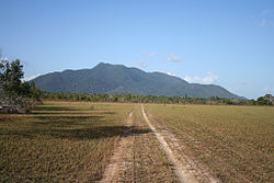
| Rupununi savannah | |
Coordinates: 2 ° 54 ′ N , 58 ° 56 ′ W
Upper Takutu-Upper Essequibo is a region in southwest Guyana ; it borders in the north on the Potaro-Siparuni region , in the east on the East Berbice-Corentyne region and in the south and west on Brazil . The cities of Lethem , Isherton , Good Hope and Surama are in the region . Upper Takutu-Upper Essequibo is the largest and least densely populated region of Guyana. The area is shaped by the Rupununi savannah, which lies between the Rupununi River and the Brazilian border.


