Västervik (municipality)
| Västervik municipality | |||||
|---|---|---|---|---|---|
|
|||||
| State : | Sweden | ||||
| Province (län): | Kalmar Lan | ||||
| Historical Province (landskap): | Småland | ||||
| Main place: | Vastervik | ||||
| SCB code: | 0883 | ||||
| Residents : | 36,679 (December 31, 2019) | ||||
| Area : | 2,026.9 km² (January 1, 2016) | ||||
| Population density : | 18.1 inhabitants / km² | ||||
| Website : | www.vastervik.se | ||||
| List of municipalities in Sweden | |||||
Coordinates: 57 ° 45 ' N , 16 ° 39' E

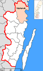
Västervik is a municipality ( Swedish kommun ) in the Swedish province of Kalmar län and the historic province of Småland . The main town of the municipality is Västervik .
geography
The municipality is characterized by a very fragmented coastline and many offshore islands. There are also many smaller lakes. The name "Tjust" is used almost synonymously for the municipality today, even if the area of the former small kingdom has historically minor deviations.
history
The name Västervik is first mentioned in connection with a place on Gamlebyviken, which was then called Västerviken. Today the place "Gamleby" (loosely translated "the old place") is located here. The spelling of Västervik has been adapted again and again, Westervik and Westerwick still appear in the names of traditional clubs today.
In 1433 the Swedish King Erik of Pomerania ordered the citizens of Västervik to move closer to the sea - to the current place at the mouth of the Gamlebyviken. In 1517 Västervik was sacked by the Danes. In 1548 the Swedish King Gustav had a shipyard built in Västervik. The city stayed out of the " Dackefejden " peasant uprising and so did not have to pay any fines. In the 17th century Västervik flourished thanks to the export of iron and wood from the wooded hinterland.
The construction of the railway Hultsfred – Norsholm – Vimmerby 1879–1906 led to further growth. A narrow-gauge branch line connected Västervik to the main line.
Towards the end of the First World War, Västervik was led by a socialist workers' council, which for a short time took control of the shipyard, the paper mill, the fishery, the nail factory, stone carving, the match factory and the mechanical workshops.
From 1863 to 1970 Västervik was the capital of "Kalmar Läns northern Landsting" (the Landsting mainly organizes health care and public transport), the creation of which reflects the competitive situation between Västervik and Kalmar in the long coastal country. Currently (2014) the municipality is examining what a "change of country" to Östergötland would mean and how this could be achieved.
Västervik became an independent city through the municipal reform in 1862. In 1967 the urban area was expanded before several municipalities were merged to form Västerviks Kommun in 1971, the main town of which has been Västervik since then.
From an ecclesiastical point of view, Västervik has belonged to the Linköping diocese since 1433.
dialect
A dialect is spoken in Västervik that is very similar to the dialects spoken in Östergötland. One can almost speak of a "coastal Maland" dialect.
economy
Västervik is one of the largest municipalities in the south of Sweden and, due to the large distance to the central locations of the neighboring municipalities, represents a separate labor market region.
Due to unemployment and the low birth rate, the population has decreased significantly in the last few decades. The population fell from around 42,000 in 1970 to around 36,000 in 2005. In order to reverse this trend, the municipality is now focusing on the economic sectors of education, communication and tourism.
Attractions
The narrow-gauge railway from Västervik to Hultsfred , which is now a museum railway, runs through the municipality . A visit to the regional museum in Västervik on the Kullbaken with changing exhibitions or the agricultural museum of Överum is also worthwhile. Another attraction is Gränsö Castle, which is located in a nature reserve with a hiking trail and bathing areas.
places
The following places are localities ( tatorter ):
Web links
- Official website (Swedish, English and German)
Individual evidence
- ↑ Folkmängd i riket, län och kommuner December 31, 2019 at Statistiska centralbyrån
- ↑ Kommunarealer January 1, 2016 at Statistiska centralbyrån (including all inland waters)

