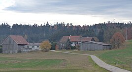
Vötschenhof
|
Vötschenhof
community Kreßberg
Coordinates: 49 ° 9 ′ 21 ″ N , 10 ° 11 ′ 41 ″ E
|
|
|---|---|
| Height : | 474 m above sea level NHN |
| Residents : | 2 (Jun 30, 2018) |
| Postal code : | 74594 |
| Area code : | 07957 |
|
The Kreßberg district of Vötschenhof
|
|
Vötschenhof is one of 33 districts of the Baden-Württemberg community of Kreßberg , which is located in the Schwäbisch Hall district .
geography
The farm is located south of the industrial area Heiligenfeld at the northeastern foot of the rest ( 528 m above sea level. NN ), a four kilometer hilly terrain in the Frankenhöhe belonging Crailsheim Hardt . Vötschenhof is located at an altitude of 474 m above sea level. NN and is about three kilometers from the southwestern village of Waldtann , in which the Kreßberg municipal administration is based.
history
The first written mention of the Vötschenhof took place in 1432 under the name Fetzenhof , when the Teutonic Order sold the homestead to the imperial city of Dinkelsbühl . In 1619, the homestead was referred to as Fetschenhof in another mention , but only a little later it was destroyed in the Thirty Years' War . Otherwise, the village essentially shared the historical fate of Leukershausen , with which it was always politically closely linked. Along with this village belonged to the yard area by the end of the Holy Roman Empire to Oberamt Crailsheim of Brandenburg-Ansbach Principality of Ansbach . When the Kingdom of Bavaria forcibly took possession of the principality in 1806 , it became temporarily Bavarian, but four years later it came into the possession of the Kingdom of Württemberg with the border treaty between Bavaria and Württemberg . With this contract, the village, which was only rebuilt in 1860, later became a border town and the current state border between Baden-Württemberg and Bavaria runs just 100 meters east of the Vötschenhof. As a result of the administrative reforms carried out in the Kingdom of Württemberg at the beginning of the 19th century, the place became part of the independent rural community of Leukershausen, which also included the hamlets of Bergertshofen , Haselhof , Selgenstadt and Waidmannsberg . Vötschenhof has been part of Kreßberg since 1973, after this entire community was reorganized from the previously independent communities of Leukershausen, Marktlustenau , Mariäkappel and Waldtann as part of the municipal territorial reform . In 2018 the Vötschenhof had two residents.
traffic
The connection to the public road network is made by a 700 meter long asphalt dirt road, which branches off the state road L 1010 a little south of Leukershausen .
literature
- The state of Baden-Württemberg. Official description by district and municipality . Administrative district of Stuttgart, regional associations of Franconia and East Württemberg. Volume IV: Stuttgart district, Franconian and East Württemberg regional associations. Kohlhammer, Stuttgart 1980, ISBN 3-17-005708-1 .
Web links
- Map of the Vötschenhof on: State Agency for the Environment Baden-Württemberg (LUBW) ( information )
- Aerial photo of the Vötschenhof on: State Institute for the Environment Baden-Württemberg (LUBW) ( information )
Individual evidence
- ↑ a b Population figures for the community of Kreßberg , accessed on November 25, 2018
- ^ The state of Baden-Württemberg. Official description by district and municipality . Administrative district of Stuttgart, regional associations of Franconia and East Württemberg. Volume IV: Stuttgart district, Franconian and East Württemberg regional associations. Kohlhammer, Stuttgart 1980, ISBN 3-17-005708-1 , p. 462-467 .
- ^ The state of Baden-Württemberg. Official description by district and municipality . Administrative district of Stuttgart, regional associations of Franconia and East Württemberg. Volume IV: Stuttgart district, Franconian and East Württemberg regional associations. Kohlhammer, Stuttgart 1980, ISBN 3-17-005708-1 , p. 463 .
- ↑ History of Vötschenhofes , accessed on November 25, 2018
- ↑ Composition of the rural community Leukershausen , accessed on November 25, 2018

