
Vallehermoso (La Gomera)
| Vallehermoso municipality | |||
|---|---|---|---|
 Vallehermoso
|
|||
| coat of arms | Map of the Canary Islands | ||

|
|
||
| Basic data | |||
| Autonomous Community : | Canary Islands | ||
| Province : | Santa Cruz de Tenerife | ||
| Island: | La Gomera | ||
| Coordinates | 28 ° 10 ′ N , 17 ° 15 ′ W | ||
| Height : | 230 msnm | ||
| Area : | 109.11 km² | ||
| Residents : | 2,901 (Jan 1, 2019) | ||
| Population density : | 26.59 inhabitants / km² | ||
| Postal code : | E-38840 (Vallehermoso) E-38849 (Macayo) E-38850 (Arguamul) E-38852 (Alojera) E-38869 (Chipude) E-38891 (Tamargada) |
||
| Municipality number ( INE ): | 38050 | ||
| administration | |||
| Mayor : | Jaime Luis Noda Morales ( PSOE ) (as of 2007) | ||
| Address of the municipal administration: | Plaza de la Constitución, 1 38840 - Vallehermoso |
||
| Website : | vallehermosoweb.es | ||
| Location of the municipality | |||

|
|||

Vallehermoso is one of the six municipalities on the Canary Island of La Gomera . It houses 2901 inhabitants (January 1, 2019) on an area of 109.11 square kilometers. This makes Vallehermoso ( in English: beautiful valley ) the second largest municipality in La Gomera after San Sebastián . The main town also bears the name Vallehermoso and was once the seat of the island's main administration.
economy
The population lives mainly from agriculture. Some dams secure the water supply for potato, tomato, banana and wine growing. Here is the center of palm honey production ( Miel de Palma ). The production of goat cheese and brandy is also worth mentioning . Some artisans who are employed in basketry , weaving and pottery , support the valley, largely untouched by tourism, economically.
Attractions
The valley is best known for the rock formation Los Organos , the organ pipes . They are basalt columns washed free from the sea , which are only visible from the ship. The municipality also includes the sources of Epina , the potters of El Cercado and the fortress of the Gomeros on the mountain La Fortaleza near Chipude .
Around a third of the Garajonay National Park is located in the municipality .
The church Iglesia de La Candelaria in Chipude from the 16th century and the church of San Juan Bautista in the center of Vallehermoso from the end of the 17th century should be noted .
The El Castillo del Mar cultural center , designed by photographer Thomas K. Müller , is located directly on the coast of Vallehermoso . He turned the old banana loading station into a center for concerts, open-air cinema and folklore performances . Many of the island's goods, especially bananas, were packed and loaded onto steamships here. In 1950 the building was shut down. Thomas K. Müller acquired the Castillo del Mar in 1981 and had it restored.
Places in the municipality of Vallehermoso
- Chipude
- El Cercado
- Arguamul
- Alojera
- Tamargada
- Tazo
- La Dama
- Macayo
- El ingenio
- Epina

Ayuntamiento (Town Hall) of Vallehermoso
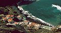
Playa de Alojera

Terraced fields near Alojera

Nuestra Señora de la Candelaria


.jpg)
Individual evidence
- ↑ Cifras oficiales de población resultantes de la revisión del Padrón municipal a 1 de enero . Population statistics from the Instituto Nacional de Estadística (population update).