
Valle Gran Rey
| Valle Gran Rey municipality | |||
|---|---|---|---|
 Valle Gran Rey
|
|||
| coat of arms | Map of the Canary Islands | ||

|
|
||
| Basic data | |||
| Autonomous Community : | Canary Islands | ||
| Province : | Santa Cruz de Tenerife | ||
| Island: | La Gomera | ||
| Coordinates | 28 ° 7 ′ N , 17 ° 19 ′ W | ||
| Height : | 100 msnm | ||
| Area : | 32.36 km² | ||
| Residents : | 4,564 (Jan 1, 2019) | ||
| Population density : | 141.04 inhabitants / km² | ||
| Postal code : | E – 38870 (Vueltas) E – 38879 (El Hornillo) E – 38852 (Tagaluche) E – 38869 (Las Hayas) E – 38892 (Arure) |
||
| Municipality number ( INE ): | 38049 | ||
| administration | |||
| Mayor : | Christopher Marrero Galván ( PSOE ) (since 2019) | ||
| Address of the municipal administration: | C / La Calera, s / n 38870 - Valle Gran Rey |
||
| Website : | www.vallegranrey.es | ||
| Location of the municipality | |||

|
|||

The Valle Gran Rey ( Valley of the Great King , Hupalupa , a king of the Gomeros is meant ) is a municipality on the Canary Island of La Gomera . The administrative seat has been La Calera since 1930 . The municipality consists of the main towns of La Calera (on the slope), La Playa, Borbalán and Vueltas (on the port) in Valle Bajo (lower valley ). The Valle Alto (upper valley) includes Granados , El Hornillo , La Vizcaïna and El Retamal , among others . Outside the valley, the municipality includes the hamlets of Taguluche , Las Hayas and Arure , the latter two close to the Garajonay National Park .
character
The valley offers an almost exotic sight thanks to its terraced cultural landscape with an abundance of palm trees , the extensive banana plantations and many scattered small houses. A particularly large number of hippies were drawn here in the 1970s and 1980s . In the meantime, the valley has been equated with dropout places like Goa or Kathmandu .
The municipality of Valle Gran Rey has by far the highest level of tourist use on the island of La Gomera . The valley has been easy to reach since the access road and the port were expanded. There was a significant increase in hotels and tourist apartment buildings from a total of around 1400 beds between 1990 and 2005. This could gradually give rise to mass tourism from the previous individual tourism .
traffic
There is only one access road to the Valle Gran Rey. This leads from the valley to the Garajonay National Park. From there the main road connects the valley with the capital and the port of San Sebastián de la Gomera.
The Valle Gran Rey is also accessible by Fred's Benchi Express ferries . Olsen Express and a car ferry from the shipping company Naviera Armas can be reached. The Benchi Express passenger ferry also goes to the port of Playa de Santiago in the south of the island. Both ferries started operating in 2017.
In previous years, after the expansion of the port in Vueltas, there were ferry connections between Valle Gran Rey and the capital. Since then, the port can also be called by merchant and cruise ships. From November 2008 to February 2009 the Garajonay Express shipping company operated a speedboat line between Los Cristianos ( Tenerife ) and Vueltas in the Valle Gran Rey. Between March 2009 the shipping company took over Fred. Olsen ran this line until February 1, 2012.
Interesting places
The Lanzarote artist César Manrique created the Mirador del Palmarejo viewpoint high above the valley with a view of the cultivated terraces all the way to the sea . You have a good view through the large panoramic windows of the restaurant inside. The restaurant was run by a vocational school for hotel and catering, but was abandoned for economic reasons.
The Mirador El Santo with the Ermita del Santo chapel is located near Arure . From there you can see Taguluche in a westerly direction.
The Salto de Agua waterfall is located in the Barranco de Arure stream above El Guro .
A statue of the Guanche rebel Hautacuperche stands at the southern beginning of the beach promenade.

The village of La Calera in the Valle Gran Rey

Mirador del Palmarejo, restaurant

The beach in the La Playa district
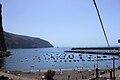
View of the port of Vueltas

Statue of the Hautacuperche rebel


Population development
| year | Residents | Population density |
|---|---|---|
| 1991 | 3,103 | 95.9 inhabitants / km² |
| 1996 | 3,631 | 112.2 inhabitants / km² |
| 2001 | 4,238 | 131.0 inhabitants / km² |
| 2006 | 5,040 | 155.8 inhabitants / km² |
| 2011 | 5,364 | 165.8 inhabitants / km² |
| 2016 | 4,285 | 132.4 inhabitants / km² |
Individual evidence
- ↑ Cifras oficiales de población resultantes de la revisión del Padrón municipal a 1 de enero . Population statistics from the Instituto Nacional de Estadística (population update).
- ↑ Tomas Niederberghaus: The stepchildren of the sun. In: Zeit Online. May 19, 2005. Retrieved February 25, 2012 .