
Administrative community Illschwang
| coat of arms | Germany map | |
|---|---|---|
 Help on coat of arms |
Coordinates: 49 ° 27 ' N , 11 ° 41' E |
|
| Basic data | ||
| Existing period: | 1978– | |
| State : | Bavaria | |
| Administrative region : | Upper Palatinate | |
| County : | Amberg-Sulzbach | |
| Area : | 116.63 km 2 | |
| Residents: | 3782 (Dec. 31, 2019) | |
| Population density : | 32 inhabitants per km 2 | |
| License plate : | AS, BUL , ESB , NAB , SUL | |
| Association key : | 09 3 71 5304 | |
| Association structure: | 2 municipalities | |
| Association administration address : |
At Dorfplatz 2 92278 Illschwang |
|
| Website : | ||
| Chairman : | Dieter Dehling | |
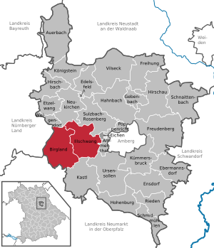
| Location of the Illschwang administrative community in the Amberg-Sulzbach district | ||
  |
||

In the administrative community Illschwang in the Upper Palatinate district of Amberg-Sulzbach , which was formed on May 1, 1978, the following communities have come together to handle their administrative business:
- Birgland , 1797 inhabitants, 62.42 km²
- Illschwang , 1985 inhabitants, 54.21 km²
The administrative community is based in Illschwang.
Individual evidence
- ↑ "Data 2" sheet, Statistical Report A1200C 202041 Population of the municipalities, districts and administrative districts 1st quarter 2020 (population based on the 2011 census) ( help ).
Administrative communities in the Amberg-Sulzbach district
Hahnbach | Illschwang | Koenigstein | Neukirchen near Sulzbach-Rosenberg
Dissolved: Ensdorf | Vineyards | Schmidmühlen | Ursensollen