
Administrative community Kühbach
| coat of arms | Germany map | |
|---|---|---|
 Help on coat of arms |
Coordinates: 48 ° 30 ' N , 11 ° 11' E |
|
| Basic data | ||
| State : | Bavaria | |
| Administrative region : | Swabia | |
| County : | Aichach-Friedberg | |
| Area : | 67.29 km 2 | |
| Residents: | 6292 (Dec. 31, 2019) | |
| Population density : | 94 inhabitants per km 2 | |
| License plate : | AIC, FDB | |
| Association key : | 09 7 71 5703 | |
| Association structure: | 2 municipalities | |
| Association administration address : |
Marktplatz 3 86556 Kühbach |
|
| Website : | ||
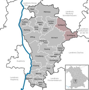
| Location of the Kühbach administrative community in the Aichach-Friedberg district | ||
  |
||

The Kühbach administrative community is located in the Swabian district of Aichach-Friedberg and is formed by the following communities:
- Kühbach , market , 4326 inhabitants, 37.5 km²
- Schiltberg , 1966 inhabitants, 29.79 km²
The administrative community is based in Kühbach.
Individual evidence
- ↑ "Data 2" sheet, Statistical Report A1200C 202041 Population of the municipalities, districts and administrative districts 1st quarter 2020 (population based on the 2011 census) ( help ).
Administrative communities in the Aichach-Friedberg district