
Administrative community Maßbach
| coat of arms | Germany map | |
|---|---|---|
 Help on coat of arms |
Coordinates: 50 ° 11 ′ N , 10 ° 17 ′ E |
|
| Basic data | ||
| State : | Bavaria | |
| Administrative region : | Lower Franconia | |
| County : | Bad Kissingen | |
| Area : | 92.22 km 2 | |
| Residents: | 6497 (Dec. 31, 2019) | |
| Population density : | 70 inhabitants per km 2 | |
| License plate : | KG, BRK, HAB | |
| Association key : | 09 6 72 5609 | |
| Association structure: | 3 municipalities | |
| Association administration address : |
Marktplatz 1 97711 Maßbach |
|
| Website : | ||
| Chairman : | Johannes Wegner | |
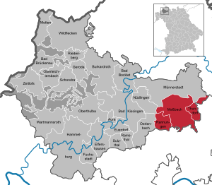
| Location of the Maßbach administrative community in the Bad Kissingen district | ||
  |
||

In the administrative community of Maßbach in the Lower Franconian district of Bad Kissingen , the following communities have come together to handle their administrative business:
- Maßbach , market , 4334 inhabitants, 59.3 km²
- Rannungen , 1133 inhabitants, 17.34 km²
- Thundorf i.UFr. , 1030 inhabitants, 15.58 km²
The seat of the administrative association is Maßbach, chairman is Johannes Wegner.
Individual evidence
- ↑ "Data 2" sheet, Statistical Report A1200C 202041 Population of the municipalities, districts and administrative districts 1st quarter 2020 (population based on the 2011 census) ( help ).
Administrative communities in the Bad Kissingen district