
Administrative community Oberding
| coat of arms | Germany map | |
|---|---|---|

|
Coordinates: 48 ° 19 ' N , 11 ° 51' E |
|
| Basic data | ||
| State : | Bavaria | |
| Administrative region : | Upper Bavaria | |
| County : | Erding | |
| Area : | 100.35 km 2 | |
| Residents: | 9272 (Dec. 31, 2019) | |
| Population density : | 92 inhabitants per km 2 | |
| License plate : | ED | |
| Association key : | 09 1 77 5123 | |
| Association structure: | 2 municipalities | |
| Association administration address : |
Tassilostr. 17 85445 Oberding |
|
| Website : | ||
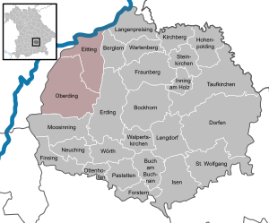
| Location of the Oberding administrative community in the Erding district | ||
  |
||

The Oberding administrative community is located in the Upper Bavarian district of Erding and is formed by the following communities:
The administrative association is based in Oberding.
Individual evidence
- ↑ "Data 2" sheet, Statistical Report A1200C 202041 Population of the municipalities, districts and administrative districts 1st quarter 2020 (population based on the 2011 census) ( help ).
Administrative communities in the district of Erding
Hörlkofen | Oberding | Oberneuching | Patties | Stone churches | Wartenberg
Resolved: Isen