
Victoria City


Victoria City , short: Victoria ( Chinese 維多利亞 城 / 维多利亚 城 , Pinyin Wéiduōlìyà Chéng , Jyutping Wai 4 do 1 lei 6 aa 3 Sing 4 ), officially City of Victoria ( historical transcription : 域 多 利 城 , Yùduōlì Chéng , Jyutping Wik 6 do 1 lei 6 Sing 4 ) are historical names for one of the first British settlements in Hong Kong , named after Queen Victoria . The city originated in the north of Hong Kong Island in the area of what is now the Central district . From there, the urban area expanded until the place name became uncommon in the 20th century.
term
Some authors, such as Steve Tsang or Michael Ingham, use Victoria City as a synonym for what is now Central . The official definition from legal texts, on the other hand, uses the term for an urban area that goes beyond Central and belongs to parts of today's Wan Chai District . The entire historical extent from then corresponds roughly to the areas of the districts of Central and Western and Wan Chai today . In contemporary Chinese texts and among the local population, the term " Four Wan and Nine Yeuk " ( 四環 九 約 / 四环 九 约 , Sìhuán-jiǔyuē , Jyutping Sei 3 waan 4 -gau 2 joek 3 , English Four Wan and Nine Yeuk - "Four Reviere, Nine Areas") a common term for the then City of Victoria until the end of the Second World War, the city limits of which are marked by boundary stones.
founding
After Hong Kong was declared a British colony in 1842 , Stanley was initially the British administrative seat. Due to fever and deaths from malaria , the British government decided to set up a new settlement in a previously uninhabited area on the north coast of Hong Kong Island .
Administrative division
Shortly after it was founded in 1844, Victoria City comprised three locations:
- Sheung Wan, west of Aberdeen Street
( 上 環 / 上 环 ) -
Chung Wan / Choong Wan / Central , former official area larger than today's definition
( 中 環 / 中 环 ) - Ha Wan, east of Glenealy, today's surroundings of Central and Admiralty
( 下 環 / 下 环 )
Nine places were described in a law enacted in 1866.
Historically also known as " Nine Yeuk " ( 九 約 / 九 约 ):
- Shek-tong Tsui
( 石塘 嘴 or 石塘咀 ) - Sai Ying Pun / Sai Ying-pun
( 西 營盤 / 西 营盘 ) -
Tai Ping Shan
( 太平山 ) - Sheung Wan / Sheong Wan
( 上 環 / 上 环 ) - Chung Wan North and South / Choong Wan North and South / Central North and South
( 中 環 北 & 中 環 南 / 中 环 北 & 中 环 南 ) - Ha Wan
( 下 環 / 下 环 ) -
Wan Chai / Wan-tsai
( 灣仔 / 湾仔 ) - Bowrington / Bowring City, today mostly: Ngo Keng
( 寶 靈頓 / 宝 灵顿 , 寶靈 城 / 宝灵 城 , today mostly: 鵝 頸 區 / 鹅 颈 区 ) - So Kun Poo / So-kon Po
( 掃 捍 埔 / 扫 捍 埔 )
The following ten locations are listed in a law enacted in 1888:
- Kennedy Town
( 堅 尼 地 城 / 坚 尼 地 城 ) - Shek Tong Tsui / Shek-tong Tsui
( 石塘 嘴 or 石塘咀 ) - Sai Ying Pun / Sai Ying-pun
( 西 營盤 / 西 营盘 ) - Tai Ping Shan
( 太平山 ) - Sheung Wan / Sheong Wan
( 上 環 / 上 环 ) - Chung Wan / Choong Wan / Central
( 中 環 / 中 环 ) - Ha Wan
( 下 環 / 下 环 ) - Wan Chai / Wan-tsai
( 灣仔 / 湾仔 ) - Bowrington / Bowring City, today mostly: Ngo Keng
( 寶 靈頓 / 宝 灵顿 , 寶靈 城 / 宝灵 城 , today mostly: 鵝 頸 區 / 鹅 颈 区 ) - So Kun Poo / So-kon Po
( 掃 捍 埔 / 扫 捍 埔 )
Official city limits
The boundaries of the City of Victoria or Town of Victoria were officially established in a law enactment in 1901. The city therefore extended from Mount Davis / Mo Sing Leng ( 摩 星 嶺 / 摩 星 岭 ) in the west to Causeway Bay in the east. Victoria Harbor served as the northern boundary and the mountain slopes 600 feet above sea level as the southern boundary. The demarcation for the City of Victoria or Victoria was carried out in a further decree in 1911 stating property numbers ( Inland Lot No. ). The southern limit was expanded to 700 feet above sea level.
The text of the law has been adapted over time, but the original official city limits have largely been preserved to this day. Even after Hong Kong was handed over to the People's Republic of China , the city limits in current laws are still valid. At the same time, the city limits do not play a role in practice today. The government uses districts as the administrative units of Hong Kong, with Victoria City comprising part of the Central and Western and Wan Chai districts.
Landmarks
In 1903, the Hong Kong government at the time set boundary stones to mark the city limits. Six stones have been preserved today, bearing the inscription " City Boundary 1903 ". A seventh stone on Magazine Gap Road at Magazine Gap mysteriously disappeared or was nowhere to be found in 2007 after road works.

Sai Ning Street, Kennedy Town
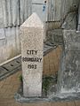
Pok Fu Lam Road, Lung Fu Shan, Mid-Levels

Hatton Road, Lung Fu Shan, Mid-Levels
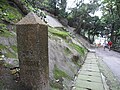
Old Peak Road, Victoria Peak

Bowen Road, Happy Valley

Wong Nai Chung Road, Happy Valley

Magazine Gap Road, Magazine Gap, Mid-Levels (disappeared landmark)


Web links
- Map of Victoria City 1964 , drawn city limits highlighted
- Photos of the boundary stones preserved today
Individual evidence
- ↑ Steve Tsang: A Modern History of Hong Kong . IB Tauris, 2007, ISBN 978-1-84511-419-0 , pp. 17 .
- ↑ Michael Ingham: Hong Kong: A Cultural History . Oxford University Press, New York City , USA 2007, ISBN 0-19-531496-4 .
- ^ Exhibition on the "City of Victoria - A Selection of the Hong Kong Museum of History's Historical Photographs" (四環 九 約 - 香港 歷史博物館 藏 歷史 圖片 精選 / 四环 九 约 - 香港 历史博物馆 藏 历史 图片 精选) - Chinese / English: online - Retrieved June 25, 2017 - lcsd.gov.hk
- ↑ Blog article on "Traces of an Old Town - Four Wan and Nine Yeuk" (「古城」 蹤影 - 《四環 九 約》 / 「古城」 踪影 - 《四环 九 约》) - Chinese: online ( Memento from 11. March 2007 in the Internet Archive ) - Retrieved June 25, 2017 - hkila.org.hk
- ↑ Patrick Hase: Historical development of the Central District , lecture on October 17, 2009. Video on YouTube . Retrieved July 12, 2013.
- ^ EJ Eitel: Europe in China. The History of Hong Kong from the Beginning to the Year 1882 , 1895. Publishers: Luzac & Company (London), Kelly & Walsh, Ld. (Hong Kong). Retrieved July 12, 2013.
- ↑ Ordinance No. 7 of 1866: Victoria Registration (PDF; 980 kB), August 16, 1866. In: Historic Laws of Hong Kong Online, Law Consolidation of 1890, page 907, paragraph 3.
- ↑ Ordinance No. 3 of 1888: Regulation of Chinese (PDF; 503 kB), May 7, 1888. In: Historic Laws of Hong Kong Online, Law Consolidation of 1901, page 577, Part III, Section 7.
- ↑ Ordinance No. 19 of 1901: Interpretation (PDF; 216 kB), October 31, 1901. In: Historic Laws of Hong Kong Online, Law Consolidation of 1901, page 990, paragraph 2.
- ↑ Ordinance No. 31 of 1911: Interpretation (PDF; 1.1 MB). In: Historic Laws of Hong Kong Online, 1912 Consolidation of Laws, 2021, Part IV, Colonial Definitions.
- ↑ Cap 1 Sched 1 Boundaries of the City of Victoria; Interpretation and General Clauses Ordinance. ( English ) In: Bilingual Laws Information System . Department of Justice. September 2, 2012. Retrieved April 21, 2013.
- ^ Boundary Stone at Magazine Gap Road , June 15, 2007. In: Gwulo: Old Hong Kong. Retrieved June 12, 2013.
- ↑ 探針 : 界石 失蹤 政府 不聞不問 , August 17, 2007. Accessed July 12, 2013.
- ↑ 專題 報道 : 第七 界石 神秘 消失 , August 19, 2007. Accessed July 12, 2013.
Coordinates: 22 ° 17 ' N , 114 ° 9' E