Vilar de Nantes
| Vilar de Nantes | ||||||
|---|---|---|---|---|---|---|
|
||||||
| Basic data | ||||||
| Region : | Norte | |||||
| Sub-region : | Alto Tâmega | |||||
| District : | Vila Real | |||||
| Concelho : | Chaves | |||||
| Coordinates : | 41 ° 43 ′ N , 7 ° 27 ′ W | |||||
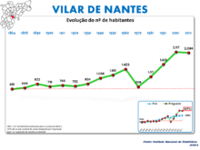
| Residents: | 2084 (as of June 30, 2011) | |||||
| Surface: | 7.28 km² (as of January 1, 2010) | |||||
| Population density : | 286 inhabitants per km² | |||||
| Postal code : | 5400-580 | |||||
| politics | ||||||
| Mayor : | Vitor Fernando Machado Batista Ferreira Alves | |||||
| Address of the municipal administration: | Junta de Freguesia de Vilar de Nantes Bairro da Sobreira 5400-580 Vilar de Nantes |
|||||
Vilar de Nantes is a village and a municipality in the north of Portugal .
history
The first mentions of Vilar de Nantes come from the 13th century. In the surveys under King D. Dinis the place was already listed as a separate municipality in 1320/21.
administration
Vilar de Nantes is a parish ( freguesia ) in the district ( concelho ) of Chaves , in the Vila Real district . On June 30, 2011 the district had 2084 inhabitants on an area of 7.3 km².
The following localities and districts are located in the municipality:
- Cascalho
- Fonte Carriça
- Lombo
- Nantes
- Santa Ovaia
- Seixal
- Sobreira
- Vale de Zirma
- Vilar de Nantes
Sons and daughters of the church
- António Joaquim de Medeiros (1846–1897), Bishop of Macau
- José Celestino da Silva (1849–1911), military and colonial administrator, 1894–1908 Governor General of Portuguese Timor
Web links
- Profile of the municipality of Vilar de Nantes on the Chaves municipality website
- Geographical data Vilar de Nantes on www.keskeces.com
- Portrait of the municipality of Vilar de Nantes on the regional portal www.espigueiro.pt
- Pictures from Vilar de Nantes on Flickr
Individual evidence
- ↑ a b www.ine.pt - indicator resident population by place of residence and sex; Decennial in the database of the Instituto Nacional de Estatística
- ↑ Overview of code assignments from Freguesias on epp.eurostat.ec.europa.eu
- ↑ Entry on the municipality of Vilar de Nantes in the archives of the Vila Real district, accessed on June 19, 2014


