
Foothills (Rhineland)

Foothill slope near Alfter

The promontory is elongated and up to 165 m above sea level. NHN high hill in North Rhine-Westphalia . It is part of the ridge of the Ville and delimits the Cologne Bay between Cologne and Bonn and the Rhein-Erft-Kreis and the Rhein-Sieg-Kreis to the west .
geography
The promontory belongs to the ridge of the Ville and refers to the eastern slopes of the Rhine valley between the district of Bonn Duisdorf and the Hürther district Kendenich ranges after the natural environment a little breakdown but further south in the Duisdorfer Lössbucht to Witterschlick (municipality Alfter ) where it is in It is bordered to the east by the higher Kottenforstterrasse , and to the north roughly to Frechen . In earlier times the two terms promontory and ville were often used synonymously.
In contrast to the straight western edge of the Ville, its eastern edge, formed by the promontory, is not tectonic , but represents a valley slope created by deep and lateral erosion of the main arm of the Ice Age Rhine that used to run along here. A special feature of the foothills is the mighty one in the lee of the Ville Aeolian loess deposit from the Quaternary , which is very fertile. The foothills are therefore characterized by intensive vegetable and fruit cultivation, often in mixed cultures . The first pure fruit estate in Germany was founded here in 1896 (see Otto Schmitz-Hübsch ). Furthermore, the foothills are one of the largest German growing areas for asparagus (see Bornheimer asparagus ).
In and on the foothills are the towns and communities of Alfter , Bornheim , Brühl and Hürth . The cities and communities Erftstadt , Swisttal , Weilerswist and Wesseling are part of the wider socio-cultural area .
In terms of natural space, the promontory corresponds to room “552.2 Villehang”.
hike
The promontory is part of the Rhineland Nature Park . The Rhineland Nature Park office in Rheinbach and the Voreifel-Touristik association publish numerous, mostly free, materials for hiking in the region. One hiking trail is the approximately nine-kilometer panorama trail through blackberry plantations and orchards, above Roisdorf from the Heimatblick restaurant . Since the restaurant has been closed, the path that leads across the site is no longer accessible. That is why the home view round was created. The Römerkanal hiking trail , which accompanies the Roman Eifel aqueduct to Cologne, also leads through the foothills in its middle stages.
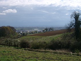
- View from the foothills towards the Rhine
spring

summer

autumn

winter


See also
Web links
- The promontory on the sides of the Rhineland Nature Park
Individual evidence
- ^ Karlheinz Paffen: Lower Rhine Bay . In: Handbook of the natural spatial structure of Germany , 6th delivery, 1959, pp. 823–844 (here: p. 835).
- ^ Hermann Josef Roth : DuMont art travel guide Bonn: from the Roman garrison to the federal capital - art and nature between the Voreifel and the Siebengebirge . DuMont, Cologne 1988, ISBN 978-3-7701-1970-7 , pp. 291/292.
- ↑ Federal Research Institute for Regional Studies and Regional Planning (ed.); Ewald Glässer (arrangement): The natural spatial units on sheet 122/123 . Self-published, Bonn-Bad Godesberg 1978, ISBN 3-87994-328-1 , p. 36. (= Geographical Land Survey 1: 200,000. Natural division of Germany )
- ↑ Jörg Grunert : Geomorphological development of the Bonn area . In: Eberhard Mayer, Klaus Fehn, Peter-Wilhelm Höllermann (eds.): Bonn - city and surrounding area. Festschrift for the 75th anniversary of the Society for Geography and Ethnology in Bonn (= work on Rhenish regional studies , issue 58). Ferdinand Dümmlers Verlag, Bonn 1988, ISBN 978-3-427-71581-8 , pp. 165-180 (here: p. 175).
- ↑ Stefan Hermes: The home view tour offers an impressive view. In: General-Anzeiger (Bonn). August 6, 2017. Retrieved June 23, 2018 .
- ↑ Home view round. In: outdooractive. October 30, 2016. Retrieved June 23, 2018 .
Coordinates: 50 ° 45 ' N , 6 ° 55' E