
Vils Engtal
|
NSG Vils-Engtal
|
||
 The nature reserve sign on the northern edge |
||
| location | Vilshofen on the Danube , Passau district , Bavaria | |
| surface | 78.54 hectares | |
| Identifier | NSG-00533.01 | |
| WDPA ID | 166060 | |
| Geographical location | 48 ° 37 ' N , 13 ° 10' E | |
|
||
| Setup date | 1997 | |

The Bavarian nature reserve Vils-Engtal is located on the lower reaches of the Vils in Vilshofen on the Danube in the Passau district .
The nature reserve was established by ordinance of August 12, 1997. It has a size of around 78.5 hectares and is located in the districts of Alkofen , Aunkirchen and in the urban area of the small town of Vilshofen on the Danube. It is a popular local recreation area, so there are well-developed bike paths with several resting places on both banks of the Vils.
Commercial granite mining
For almost 100 years - until the middle of the Second World War - granite was mined in the lower reaches of the Vils , which was transported via a field railway system to Taferl freight station and then on the Vilshofen – Aidenbach railway to nearby Vilshofen. After the mining activity has ceased, nature "takes" the area back. Quarrying sites below the water table were partially filled with water again. This is how the Taferlsee was created . The remains of the granite mining along the Vils are still visible today.
There are three hydropower plants in the Vils Engtal nature reserve .
gallery

Vilsauen of the nature reserve near Aunkirchen

The Vils in the nature reserve

The Vilskraftwerk of the city of Vilshofen on the Danube

A remnant of the former mining workers in the nature reserve: the transformer tower
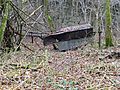
The remains of the mechanical scales with which the stones were weighed before being transported by rail


Web links
- Ordinance on the nature reserve "Vils-Engtal" (PDF file; 45 kB)
