
Vlist (Krimpenerwaard)
 flag |
 coat of arms |
| province |
|
| local community | Krimpenerwaard |
|
Area - land - water |
10.09 km 2 9.53 km 2 0.56 km 2 |
| Residents | 635 (Jan. 1, 2017) |
| Coordinates | 51 ° 59 ′ N , 4 ° 47 ′ E |
| Important traffic route |
|
| prefix | 0182 |
| Postcodes | 2803, 2821, 2851, 2855, 2861, 2871, 3415 |
Vlist ( ) is a village and a former municipality in the Dutch province of South Holland . On January 1, 2015, it was incorporated into the municipality of Krimpenerwaard . The community had 9,740 inhabitants (as of December 31, 2014) on an area of 56.51 km² (of which 2.79 km² was water).
The municipality was named after the river Vlist , which flows through the municipality.
places
Haastrecht , Stolwijk (seat of the former municipality) and Vlist , the smallest town in the municipality.
politics
Distribution of seats in the municipal council
| Political party | Seats | |||
|---|---|---|---|---|
| 1998 | 2002 | 2006 | 2010 | |
| Vrije Kiesvereniging-Gemeentebelangen | 4th | 5 | 4th | 5 |
| ChristenUnie / SGP | - | 2 | 2 | 3 |
| CDA | 3 | 3 | 3 | 2 |
| VVD | 2 | 2 | 2 | 2 |
| PvdA | 2 | 1 | 2 | 1 |
| SGP / RPF | 2 | - | - | - |
| total | 13 | 13 | 13 | 13 |
photos

Vlist in the municipality of Vlist (the small green point in the light green area)

Haastrecht, Mühle: boezemmolen number 6
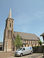
Stolwijk, the reformed church

Stolwijk, bridge verkeersbrug noordelijk

Benedenkerk, Vliet in the polder
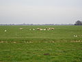
Vlist polders

Polder Stein from Tiendweg near Hekendorp


Web links
Individual evidence
- ↑ Kerncijfers wijken en buurten 2017 Centraal Bureau voor de Statistiek , accessed on June 3, 2018 (Dutch)
- ↑ Bevolkingsontwikkeling; regio per maand Centraal Bureau voor de Statistiek , accessed on June 3, 2018 (Dutch)
- ↑ Allocation of seats in the municipal council: 1998–2002 2006 2010 , accessed on June 3, 2018 (Dutch)